Villeneuve-sous-Dammartin geodata
Villeneuve-sous-Dammartin (Île-de-France) is a populated place; located in France in Europe/Paris (GMT+2) time zone. With population of 582 people, there are 13612 cities with bigger population in this country. Compared to other cities in France, 80.5% of cities are located further ↓South; 52.6% of cities are located further ←West and 64.9% of cities have higher elevation than Villeneuve-sous-Dammartin. Note1
Administrative division(s):
- Level 1: Île-de-France
- Level 2: Seine-et-Marne
- Level 3: Arrondissement de Meaux
- Level 4: Villeneuve-sous-Dammartin
Current local time in Villeneuve-sous-Dammartin:
02:05 PM, MondayDifference from your time zone: hours


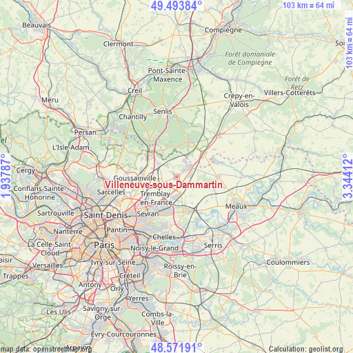
Villeneuve-sous-Dammartin GPS coordinates[2]
49° 2' 6.036" North, 2° 38' 27.6" East
| Map corner | latitude | longitude |
|---|---|---|
| Upper-left | 49.49384°, | 1.93787° |
| Center: | 49.03501°, | 2.641° |
| Lower-right: | 48.57191°, | 3.34412° |
| Map W x H: | 102.5×102.5 km | = 63.7×63.7mi |
| max Lat: | 51.07786° ⇑19.5% North |
| Villeneuve-sous-Dammartin: | 49.03501° |
| min Lat: | ⇓80.5% South 41.3874° |
| min Long | Villeneuve-sous | max Long |
| -5.08615° | 2.641° | 9.52242° |
| W 52.6%⇐ | ⇒47.4% E |
Elevation
Elevation of Villeneuve-sous-Dammartin is 90 m = 295 ft, and this is 103.7 m = 340 ft below average elevation for this country.
| Max E: |
2333 m = 7654 ft | 64.9% |
| Avg. | 193.7 m = 635 ft | |
| Villeneuve-sous-Dammartin | 90 m = 295 ft | |
Min E: |
-1 m = -3 ft | 35.1% |
See also: France elevation on elevation.city.
Geographical zone
Villeneuve-sous-Dammartin is located in North temperate zone (between Tropic of Cancer and the Arctic Circle). Distance of this North polar circle is 1949 km =1211.1 mi to North.| Distance of | km | miles | from Villeneuve-sous-Dammartin |
|---|---|---|---|
| North Pole | 4554.9 | 2830.3 | to North |
| Arctic Circle | 1949 | 1211.1 | to North |
| Tropic Cancer | 2846.3 | 1768.6 | to South |
| Equator | 5452.2 | 3387.8 | to South |


Nearby cities:
15 places around Villeneuve-sous-Dammartin: (largest is in red/bold)
• Compans
4.8 km =3 mi,  159°
159°
• Dammartin-en-Goële
3.4 km =2.1 mi,  51°
51°
• Juilly
5.3 km =3.3 mi,  116°
116°
• Le Mesnil-Amelot
3.9 km =2.4 mi,  240°
240°
• Longperrier
2.3 km =1.4 mi, 50°
• Mitry-Mory
6 km =3.7 mi,  197°
197°
• Moussy-le-Neuf
4.3 km =2.7 mi,  319°
319°
• Moussy-le-Vieux
1.8 km =1.1 mi, 318°
• Othis
5 km =3.1 mi,  29°
29°
• Rouvres
6.3 km =3.9 mi,  61°
61°
• Saint-Mard
4 km =2.5 mi,  86°
86°
• Saint-Mesmes
6.8 km =4.2 mi,  145°
145°
• Thieux
3.8 km =2.4 mi,  143°
143°
• Villeron
7.6 km =4.7 mi,  289°
289°
• Vémars
6.6 km =4.1 mi,  305°
305°
Sources, notices
• [Note1] Compared only with cities in France existing in our database
• [Src1] Map data: © OpenStreetMap contributors (CC-BY-SA)
• [Src2] Other city data from geonames.org with taken over terms of usage.
• [Src3] Geographical zone / Annual Mean Temperature by Robert A. Rohde @ Wikipedia
