Dammartin-en-Goële geodata
Dammartin-en-Goële (Île-de-France) is a populated place; located in France in Europe/Paris (GMT+2) time zone. With population of 8,552 people, there are 1127 cities with bigger population in this country. Compared to other cities in France, 81% of cities are located further ↓South; 53.1% of cities are located further ←West and 60.3% of cities have lower elevation than Dammartin-en-Goële. Note1
Administrative division(s):
- Level 1: Île-de-France
- Level 2: Seine-et-Marne
- Level 3: Arrondissement de Meaux
- Level 4: Dammartin-en-Goële


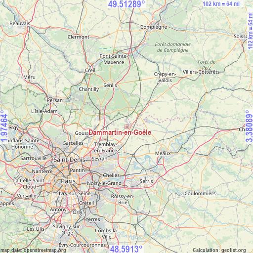
Dammartin-en-Goële GPS coordinates[2]
49° 3' 15.228" North, 2° 40' 39.972" East
| Map corner | latitude | longitude |
|---|---|---|
| Upper-left | 49.51289°, | 1.97464° |
| Center: | 49.05423°, | 2.67777° |
| Lower-right: | 48.5913°, | 3.38089° |
| Map W x H: | 102.5×102.5 km | = 63.7×63.7mi |
| max Lat: | 51.07786° ⇑19% North |
| Dammartin-en-Goële: | 49.05423° |
| min Lat: | ⇓81% South 41.3874° |
| min Long | Dammartin-en-Go | max Long |
| -5.08615° | 2.67777° | 9.52242° |
| W 53.1%⇐ | ⇒46.9% E |
Elevation
Elevation of Dammartin-en-Goële is 171 m = 561 ft, and this is 22.7 m = 74 ft below average elevation for this country.
| Max E: |
2333 m = 7654 ft | 39.7% |
| Avg. | 193.7 m = 635 ft | |
| Dammartin-en-Goële | 171 m = 561 ft | |
Min E: |
-1 m = -3 ft | 60.3% |
See also: France elevation on elevation.city.
Geographical zone
Dammartin-en-Goële is located in North temperate zone (between Tropic of Cancer and the Arctic Circle). Distance of this North polar circle is 1946.9 km =1209.7 mi to North.| Distance of | km | miles | from Dammartin-en-Goële |
|---|---|---|---|
| North Pole | 4552.7 | 2828.9 | to North |
| Arctic Circle | 1946.9 | 1209.7 | to North |
| Tropic Cancer | 2848.4 | 1769.9 | to South |
| Equator | 5454.3 | 3389.1 | to South |


Nearby cities:
15 places around Dammartin-en-Goële: (largest is in red/bold)
• Compans
6.7 km =4.2 mi,  188°
188°
• Juilly
4.9 km =3 mi,  155°
155°
• Lagny-le-Sec
6.1 km =3.8 mi,  52°
52°
• Le Mesnil-Amelot
7.3 km =4.5 mi,  236°
236°
• Le Plessis-Belleville
7.3 km =4.5 mi, 51°
• Longperrier
1.1 km =0.7 mi,  233°
233°
• Montgé-en-Goële
5.8 km =3.6 mi,  113°
113°
• Moussy-le-Neuf
5.6 km =3.5 mi,  281°
281°
• Moussy-le-Vieux
3.9 km =2.4 mi,  258°
258°
• Othis
2.2 km =1.4 mi,  354°
354°
• Rouvres
3 km =1.9 mi,  72°
72°
• Saint-Mard
2.3 km =1.4 mi,  144°
144°
• Thieux
5.2 km =3.2 mi,  184°
184°
• Ver-sur-Launette
5.7 km =3.5 mi,  4°
4°
• Villeneuve-sous-Dammartin
3.4 km =2.1 mi, 231°
Sources, notices
• [Note1] Compared only with cities in France existing in our database
• [Src1] Map data: © OpenStreetMap contributors (CC-BY-SA)
• [Src2] Other city data from geonames.org with taken over terms of usage.
• [Src3] Geographical zone / Annual Mean Temperature by Robert A. Rohde @ Wikipedia
