Moussy-le-Vieux geodata
Moussy-le-Vieux (Île-de-France) is a populated place; located in France in Europe/Paris (GMT+2) time zone. With population of 1,102 people, there are 8120 cities with bigger population in this country. Compared to other cities in France, 80.8% of cities are located further ↓South; 52.4% of cities are located further ←West and 66% of cities have higher elevation than Moussy-le-Vieux. Note1
Administrative division(s):
- Level 1: Île-de-France
- Level 2: Seine-et-Marne
- Level 3: Arrondissement de Meaux
- Level 4: Moussy-le-Vieux


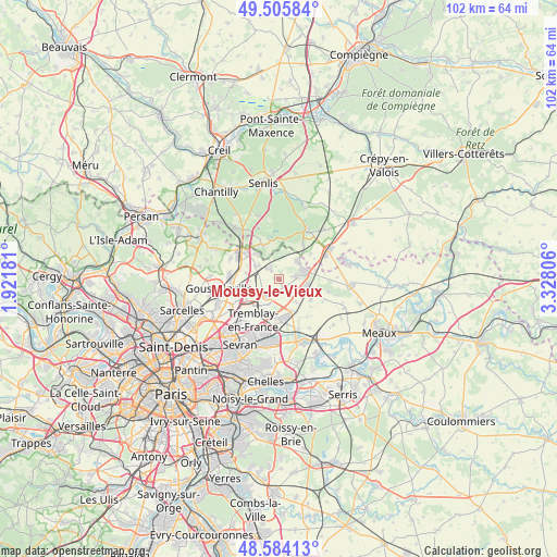
Moussy-le-Vieux GPS coordinates[2]
49° 2' 49.632" North, 2° 37' 29.748" East
| Map corner | latitude | longitude |
|---|---|---|
| Upper-left | 49.50584°, | 1.92181° |
| Center: | 49.04712°, | 2.62493° |
| Lower-right: | 48.58413°, | 3.32806° |
| Map W x H: | 102.5×102.5 km | = 63.7×63.7mi |
| max Lat: | 51.07786° ⇑19.2% North |
| Moussy-le-Vieux: | 49.04712° |
| min Lat: | ⇓80.8% South 41.3874° |
| min Long | Moussy-le-Vieux | max Long |
| -5.08615° | 2.62493° | 9.52242° |
| W 52.4%⇐ | ⇒47.6% E |
Elevation
Elevation of Moussy-le-Vieux is 87 m = 285 ft, and this is 106.7 m = 350 ft below average elevation for this country.
| Max E: |
2333 m = 7654 ft | 66% |
| Avg. | 193.7 m = 635 ft | |
| Moussy-le-Vieux | 87 m = 285 ft | |
Min E: |
-1 m = -3 ft | 34% |
See also: France elevation on elevation.city.
Geographical zone
Moussy-le-Vieux is located in North temperate zone (between Tropic of Cancer and the Arctic Circle). Distance of this North polar circle is 1947.6 km =1210.2 mi to North.| Distance of | km | miles | from Moussy-le-Vieux |
|---|---|---|---|
| North Pole | 4553.5 | 2829.4 | to North |
| Arctic Circle | 1947.6 | 1210.2 | to North |
| Tropic Cancer | 2847.6 | 1769.4 | to South |
| Equator | 5453.5 | 3388.6 | to South |


Nearby cities:
15 places around Moussy-le-Vieux: (largest is in red/bold)
• Compans
6.5 km =4 mi,  153°
153°
• Dammartin-en-Goële
3.9 km =2.4 mi,  78°
78°
• Juilly
7 km =4.3 mi,  122°
122°
• Le Mesnil-Amelot
3.9 km =2.4 mi,  214°
214°
• Longperrier
3 km =1.9 mi,  87°
87°
• Moussy-le-Neuf
2.5 km =1.6 mi,  319°
319°
• Othis
4.7 km =2.9 mi,  50°
50°
• Plailly
6.8 km =4.2 mi,  335°
335°
• Rouvres
6.9 km =4.3 mi, 75°
• Saint-Mard
5.3 km =3.3 mi,  102°
102°
• Saint-Witz
6.3 km =3.9 mi, 321°
• Thieux
5.6 km =3.5 mi,  141°
141°
• Villeneuve-sous-Dammartin
1.8 km =1.1 mi, 138°
• Villeron
6.1 km =3.8 mi,  281°
281°
• Vémars
4.9 km =3 mi,  300°
300°
Sources, notices
• [Note1] Compared only with cities in France existing in our database
• [Src1] Map data: © OpenStreetMap contributors (CC-BY-SA)
• [Src2] Other city data from geonames.org with taken over terms of usage.
• [Src3] Geographical zone / Annual Mean Temperature by Robert A. Rohde @ Wikipedia
