Josnes geodata
Josnes (Centre) is a populated place; located in France in Europe/Paris (GMT+2) time zone. With population of 971 people, there are 9054 cities with bigger population in this country. Compared to other cities in France, 55.6% of cities are located further ↓South; 62.7% of cities are located further →East and 55.6% of cities have higher elevation than Josnes. Note1
Administrative division(s):
- Level 1: Centre
- Level 2: Département du Loir-et-Cher
- Level 3: Arrondissement de Blois
- Level 4: Josnes


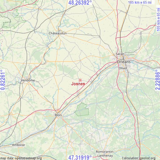
Josnes GPS coordinates[2]
47° 47' 37.32" North, 1° 31' 32.628" East
| Map corner | latitude | longitude |
|---|---|---|
| Upper-left | 48.26392°, | 0.82261° |
| Center: | 47.7937°, | 1.52573° |
| Lower-right: | 47.31919°, | 2.22886° |
| Map W x H: | 105×105 km | = 65.2×65.2mi |
| max Lat: | 51.07786° ⇑44.4% North |
| Josnes: | 47.7937° |
| min Lat: | ⇓55.6% South 41.3874° |
| min Long | Josnes | max Long |
| -5.08615° | 1.52573° | 9.52242° |
| W 37.3%⇐ | ⇒62.7% E |
Elevation
Elevation of Josnes is 115 m = 377 ft, and this is 78.7 m = 258 ft below average elevation for this country.
| Max E: |
2333 m = 7654 ft | 55.6% |
| Avg. | 193.7 m = 635 ft | |
| Josnes | 115 m = 377 ft | |
Min E: |
-1 m = -3 ft | 44.4% |
See also: France elevation on elevation.city.
Geographical zone
Josnes is located in North temperate zone (between Tropic of Cancer and the Arctic Circle). Distance of this North polar circle is 2087 km =1296.8 mi to North.| Distance of | km | miles | from Josnes |
|---|---|---|---|
| North Pole | 4692.9 | 2916 | to North |
| Arctic Circle | 2087 | 1296.8 | to North |
| Tropic Cancer | 2708.2 | 1682.8 | to South |
| Equator | 5314.2 | 3302.1 | to South |


Nearby cities:
15 places around Josnes: (largest is in red/bold)
• Avaray
8.4 km =5.2 mi,  159°
159°
• Baule
11.1 km =6.9 mi,  80°
80°
• Beaugency
7.7 km =4.8 mi,  101°
101°
• Cravant
5.1 km =3.2 mi,  41°
41°
• La Chapelle-Saint-Martin-en-Plaine
11.8 km =7.3 mi,  223°
223°
• Lailly-en-Val
12.3 km =7.6 mi, 102°
• Le Bardon
11 km =6.8 mi,  58°
58°
• Marchenoir
10.3 km =6.4 mi,  289°
289°
• Mer
9.9 km =6.2 mi,  188°
188°
• Messas
8.4 km =5.2 mi, 79°
• Ouzouer-le-Marché
13 km =8.1 mi,  0°
0°
• Saint-Laurent-Nouan
10.2 km =6.3 mi,  147°
147°
• Saint-Léonard-en-Beauce
11.7 km =7.3 mi, 292°
• Tavers
7.5 km =4.7 mi,  120°
120°
• Villorceau
5.4 km =3.4 mi, 81°
Sources, notices
• [Note1] Compared only with cities in France existing in our database
• [Src1] Map data: © OpenStreetMap contributors (CC-BY-SA)
• [Src2] Other city data from geonames.org with taken over terms of usage.
• [Src3] Geographical zone / Annual Mean Temperature by Robert A. Rohde @ Wikipedia
