Baule geodata
Baule (Centre) is a populated place; located in France in Europe/Paris (GMT+2) time zone. With population of 1,802 people, there are 5270 cities with bigger population in this country. Compared to other cities in France, 55.9% of cities are located further ↓South; 60.7% of cities are located further →East and 59.4% of cities have higher elevation than Baule. Note1
Administrative division(s):
- Level 1: Centre
- Level 2: Loiret
- Level 3: Arrondissement d’Orléans
- Level 4: Baule


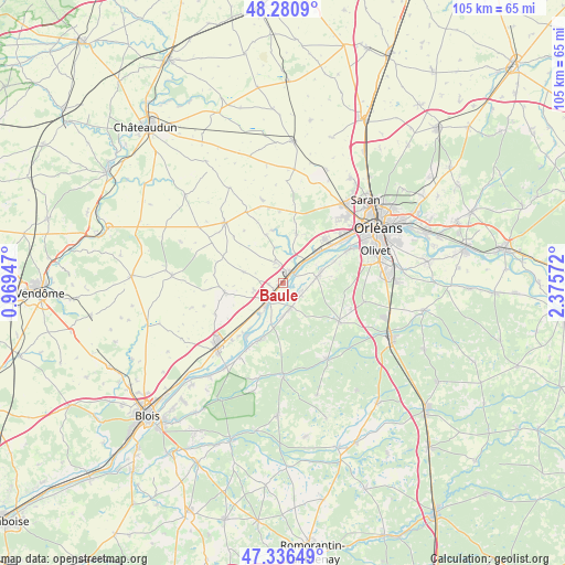
Baule GPS coordinates[2]
47° 48' 39.024" North, 1° 40' 21.324" East
| Map corner | latitude | longitude |
|---|---|---|
| Upper-left | 48.2809°, | 0.96947° |
| Center: | 47.81084°, | 1.67259° |
| Lower-right: | 47.33649°, | 2.37572° |
| Map W x H: | 105×105 km | = 65.2×65.2mi |
| max Lat: | 51.07786° ⇑44.1% North |
| Baule: | 47.81084° |
| min Lat: | ⇓55.9% South 41.3874° |
| min Long | Baule | max Long |
| -5.08615° | 1.67259° | 9.52242° |
| W 39.3%⇐ | ⇒60.7% E |
Elevation
Elevation of Baule is 104 m = 341 ft, and this is 89.7 m = 294 ft below average elevation for this country.
| Max E: |
2333 m = 7654 ft | 59.4% |
| Avg. | 193.7 m = 635 ft | |
| Baule | 104 m = 341 ft | |
Min E: |
-1 m = -3 ft | 40.6% |
See also: France elevation on elevation.city.
Geographical zone
Baule is located in North temperate zone (between Tropic of Cancer and the Arctic Circle). Distance of this North polar circle is 2085.1 km =1295.6 mi to North.| Distance of | km | miles | from Baule |
|---|---|---|---|
| North Pole | 4691 | 2914.9 | to North |
| Arctic Circle | 2085.1 | 1295.6 | to North |
| Tropic Cancer | 2710.1 | 1684 | to South |
| Equator | 5316.1 | 3303.3 | to South |


Nearby cities:
15 places around Baule: (largest is in red/bold)
• Baccon
9.5 km =5.9 mi,  339°
339°
• Beaugency
4.8 km =3 mi,  224°
224°
• Cléry-Saint-André
6 km =3.7 mi,  77°
77°
• Cravant
7.8 km =4.8 mi,  284°
284°
• Dry
3.5 km =2.2 mi,  118°
118°
• Huisseau-sur-Mauves
9.4 km =5.8 mi,  13°
13°
• Lailly-en-Val
4.7 km =2.9 mi,  167°
167°
• Le Bardon
4.1 km =2.5 mi, 338°
• Mareau-aux-Prés
10.3 km =6.4 mi,  53°
53°
• Messas
2.7 km =1.7 mi,  261°
261°
• Meung-sur-Loire
2.9 km =1.8 mi,  37°
37°
• Mézières-lez-Cléry
9.8 km =6.1 mi,  86°
86°
• Saint-Ay
7.9 km =4.9 mi, 47°
• Tavers
7.3 km =4.5 mi, 217°
• Villorceau
5.7 km =3.5 mi, 258°
Sources, notices
• [Note1] Compared only with cities in France existing in our database
• [Src1] Map data: © OpenStreetMap contributors (CC-BY-SA)
• [Src2] Other city data from geonames.org with taken over terms of usage.
• [Src3] Geographical zone / Annual Mean Temperature by Robert A. Rohde @ Wikipedia
