Cravant geodata
Cravant (Centre) is a populated place; located in France in Europe/Paris (GMT+2) time zone. With population of 880 people, there are 9818 cities with bigger population in this country. Compared to other cities in France, 56.3% of cities are located further ↓South; 62.1% of cities are located further →East and 55.2% of cities have higher elevation than Cravant. Note1
Administrative division(s):
- Level 1: Centre
- Level 2: Loiret
- Level 3: Arrondissement d’Orléans
- Level 4: Cravant


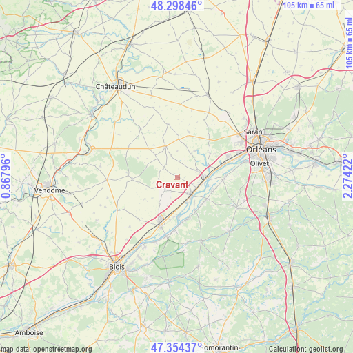
Cravant GPS coordinates[2]
47° 49' 42.816" North, 1° 34' 15.924" East
| Map corner | latitude | longitude |
|---|---|---|
| Upper-left | 48.29846°, | 0.86796° |
| Center: | 47.82856°, | 1.57109° |
| Lower-right: | 47.35437°, | 2.27422° |
| Map W x H: | 105×105 km | = 65.2×65.2mi |
| max Lat: | 51.07786° ⇑43.7% North |
| Cravant: | 47.82856° |
| min Lat: | ⇓56.3% South 41.3874° |
| min Long | Cravant | max Long |
| -5.08615° | 1.57109° | 9.52242° |
| W 37.9%⇐ | ⇒62.1% E |
Elevation
Elevation of Cravant is 116 m = 381 ft, and this is 77.7 m = 255 ft below average elevation for this country.
| Max E: |
2333 m = 7654 ft | 55.2% |
| Avg. | 193.7 m = 635 ft | |
| Cravant | 116 m = 381 ft | |
Min E: |
-1 m = -3 ft | 44.8% |
See also: France elevation on elevation.city.
Geographical zone
Cravant is located in North temperate zone (between Tropic of Cancer and the Arctic Circle). Distance of this North polar circle is 2083.1 km =1294.4 mi to North.| Distance of | km | miles | from Cravant |
|---|---|---|---|
| North Pole | 4689 | 2913.6 | to North |
| Arctic Circle | 2083.1 | 1294.4 | to North |
| Tropic Cancer | 2712.1 | 1685.2 | to South |
| Equator | 5318 | 3304.5 | to South |


Nearby cities:
15 places around Cravant: (largest is in red/bold)
• Avaray
11.8 km =7.3 mi,  182°
182°
• Baccon
8.2 km =5.1 mi,  31°
31°
• Baule
7.8 km =4.8 mi,  104°
104°
• Beaugency
6.8 km =4.2 mi,  142°
142°
• Binas
11.7 km =7.3 mi,  315°
315°
• Charsonville
11.1 km =6.9 mi,  3°
3°
• Dry
11.2 km =7 mi,  108°
108°
• Josnes
5.1 km =3.2 mi,  221°
221°
• Lailly-en-Val
10.8 km =6.7 mi,  127°
127°
• Le Bardon
6.3 km =3.9 mi,  73°
73°
• Messas
5.4 km =3.4 mi,  115°
115°
• Meung-sur-Loire
9.3 km =5.8 mi,  88°
88°
• Ouzouer-le-Marché
9.7 km =6 mi,  339°
339°
• Tavers
8.3 km =5.2 mi,  158°
158°
• Villorceau
3.6 km =2.2 mi,  147°
147°
Sources, notices
• [Note1] Compared only with cities in France existing in our database
• [Src1] Map data: © OpenStreetMap contributors (CC-BY-SA)
• [Src2] Other city data from geonames.org with taken over terms of usage.
• [Src3] Geographical zone / Annual Mean Temperature by Robert A. Rohde @ Wikipedia
