Jargeau geodata
Jargeau (Centre) is a populated place; located in France in Europe/Paris (GMT+2) time zone. With population of 4,237 people, there are 2323 cities with bigger population in this country. Compared to other cities in France, 56.8% of cities are located further ↓South; 55.4% of cities are located further →East and 59.7% of cities have higher elevation than Jargeau. Note1
Administrative division(s):
- Level 1: Centre
- Level 2: Loiret
- Level 3: Arrondissement d’Orléans
- Level 4: Jargeau


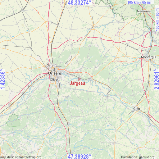
Jargeau GPS coordinates[2]
47° 51' 47.376" North, 2° 7' 35.328" East
| Map corner | latitude | longitude |
|---|---|---|
| Upper-left | 48.33274°, | 1.42336° |
| Center: | 47.86316°, | 2.12648° |
| Lower-right: | 47.38928°, | 2.82961° |
| Map W x H: | 104.9×104.9 km | = 65.2×65.2mi |
| max Lat: | 51.07786° ⇑43.2% North |
| Jargeau: | 47.86316° |
| min Lat: | ⇓56.8% South 41.3874° |
| min Long | Jargeau | max Long |
| -5.08615° | 2.12648° | 9.52242° |
| W 44.6%⇐ | ⇒55.4% E |
Elevation
Elevation of Jargeau is 103 m = 338 ft, and this is 90.7 m = 298 ft below average elevation for this country.
| Max E: |
2333 m = 7654 ft | 59.7% |
| Avg. | 193.7 m = 635 ft | |
| Jargeau | 103 m = 338 ft | |
Min E: |
-1 m = -3 ft | 40.3% |
See also: France elevation on elevation.city.
Geographical zone
Jargeau is located in North temperate zone (between Tropic of Cancer and the Arctic Circle). Distance of this North polar circle is 2079.3 km =1292 mi to North.| Distance of | km | miles | from Jargeau |
|---|---|---|---|
| North Pole | 4685.2 | 2911.2 | to North |
| Arctic Circle | 2079.3 | 1292 | to North |
| Tropic Cancer | 2716 | 1687.6 | to South |
| Equator | 5321.9 | 3306.9 | to South |


Nearby cities:
15 places around Jargeau: (largest is in red/bold)
• Boigny-sur-Bionne
11.3 km =7 mi,  313°
313°
• Bou
6 km =3.7 mi,  281°
281°
• Châteauneuf-sur-Loire
6.9 km =4.3 mi,  87°
87°
• Chécy
8.4 km =5.2 mi,  293°
293°
• Darvoy
2 km =1.2 mi,  254°
254°
• Donnery
6 km =3.7 mi,  343°
343°
• Fay-aux-Loges
7.2 km =4.5 mi,  8°
8°
• Férolles
3.4 km =2.1 mi,  199°
199°
• Germigny-des-Prés
10.9 km =6.8 mi,  100°
100°
• Mardié
5.7 km =3.5 mi,  296°
296°
• Sandillon
7.4 km =4.6 mi, 254°
• Sigloy
8.1 km =5 mi,  113°
113°
• Tigy
9.4 km =5.8 mi,  145°
145°
• Vennecy
11.5 km =7.1 mi,  332°
332°
• Vienne-en-Val
7 km =4.3 mi,  175°
175°
Sources, notices
• [Note1] Compared only with cities in France existing in our database
• [Src1] Map data: © OpenStreetMap contributors (CC-BY-SA)
• [Src2] Other city data from geonames.org with taken over terms of usage.
• [Src3] Geographical zone / Annual Mean Temperature by Robert A. Rohde @ Wikipedia
