Férolles geodata
Férolles (Centre) is a populated place; located in France in Europe/Paris (GMT+2) time zone. With population of 1,198 people, there are 7546 cities with bigger population in this country. Compared to other cities in France, 56.4% of cities are located further ↓South; 55.7% of cities are located further →East and 60.4% of cities have higher elevation than Férolles. Note1
Administrative division(s):
- Level 1: Centre
- Level 2: Loiret
- Level 3: Arrondissement d’Orléans
- Level 4: Férolles


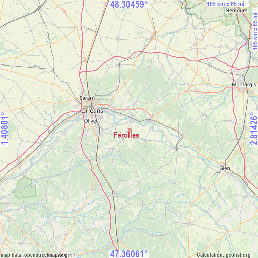
Férolles GPS coordinates[2]
47° 50' 5.1" North, 2° 6' 40.068" East
| Map corner | latitude | longitude |
|---|---|---|
| Upper-left | 48.30459°, | 1.40801° |
| Center: | 47.83475°, | 2.11113° |
| Lower-right: | 47.36061°, | 2.81426° |
| Map W x H: | 105×105 km | = 65.2×65.2mi |
| max Lat: | 51.07786° ⇑43.6% North |
| Férolles: | 47.83475° |
| min Lat: | ⇓56.4% South 41.3874° |
| min Long | Férolles | max Long |
| -5.08615° | 2.11113° | 9.52242° |
| W 44.3%⇐ | ⇒55.7% E |
Elevation
Elevation of Férolles is 101 m = 331 ft, and this is 92.7 m = 304 ft below average elevation for this country.
| Max E: |
2333 m = 7654 ft | 60.4% |
| Avg. | 193.7 m = 635 ft | |
| Férolles | 101 m = 331 ft | |
Min E: |
-1 m = -3 ft | 39.6% |
See also: France elevation on elevation.city.
Geographical zone
Férolles is located in North temperate zone (between Tropic of Cancer and the Arctic Circle). Distance of this North polar circle is 2082.4 km =1293.9 mi to North.| Distance of | km | miles | from Férolles |
|---|---|---|---|
| North Pole | 4688.3 | 2913.2 | to North |
| Arctic Circle | 2082.4 | 1293.9 | to North |
| Tropic Cancer | 2712.8 | 1685.7 | to South |
| Equator | 5318.7 | 3304.9 | to South |


Nearby cities:
15 places around Férolles: (largest is in red/bold)
• Bou
6.5 km =4 mi,  312°
312°
• Châteauneuf-sur-Loire
8.8 km =5.5 mi,  66°
66°
• Chécy
9.3 km =5.8 mi,  315°
315°
• Darvoy
2.7 km =1.7 mi,  342°
342°
• Donnery
8.9 km =5.5 mi,  356°
356°
• Fay-aux-Loges
10.5 km =6.5 mi,  11°
11°
• Jargeau
3.4 km =2.1 mi,  19°
19°
• Marcilly-en-Villette
10.2 km =6.3 mi,  220°
220°
• Mardié
7 km =4.3 mi, 324°
• Neuvy-en-Sullias
10.9 km =6.8 mi,  114°
114°
• Saint-Cyr-en-Val
10.8 km =6.7 mi,  268°
268°
• Sandillon
6 km =3.7 mi,  280°
280°
• Sigloy
8.6 km =5.3 mi,  90°
90°
• Tigy
7.9 km =4.9 mi,  125°
125°
• Vienne-en-Val
4.2 km =2.6 mi,  155°
155°
Sources, notices
• [Note1] Compared only with cities in France existing in our database
• [Src1] Map data: © OpenStreetMap contributors (CC-BY-SA)
• [Src2] Other city data from geonames.org with taken over terms of usage.
• [Src3] Geographical zone / Annual Mean Temperature by Robert A. Rohde @ Wikipedia
