Izel-lès-Équerchin geodata
Izel-lès-Équerchin (Hauts-de-France) is a populated place; located in France in Europe/Paris (GMT+2) time zone. With population of 805 people, there are 10549 cities with bigger population in this country. Compared to other cities in France, 96.1% of cities are located further ↓South; 57.1% of cities are located further ←West and 87.8% of cities have higher elevation than Izel-lès-Équerchin. Note1
Administrative division(s):
- Level 1: Hauts-de-France
- Level 2: Pas-de-Calais
- Level 3: Arras
- Level 4: Izel-lès-Équerchin


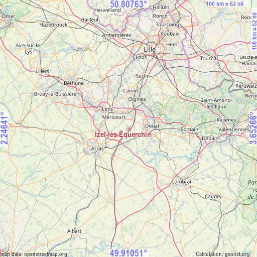
Izel-lès-Équerchin GPS coordinates[2]
50° 21' 40.284" North, 2° 56' 58.308" East
| Map corner | latitude | longitude |
|---|---|---|
| Upper-left | 50.80763°, | 2.24641° |
| Center: | 50.36119°, | 2.94953° |
| Lower-right: | 49.91051°, | 3.65266° |
| Map W x H: | 99.8×99.7 km | = 62×62mi |
| max Lat: | 51.07786° ⇑3.9% North |
| Izel-lès-Équerchin: | 50.36119° |
| min Lat: | ⇓96.1% South 41.3874° |
| min Long | Izel-lès-Éque | max Long |
| -5.08615° | 2.94953° | 9.52242° |
| W 57.1%⇐ | ⇒42.9% E |
Elevation
Elevation of Izel-lès-Équerchin is 35 m = 115 ft, and this is 158.7 m = 521 ft below average elevation for this country.
| Max E: |
2333 m = 7654 ft | 87.8% |
| Avg. | 193.7 m = 635 ft | |
| Izel-lès-Équerchin | 35 m = 115 ft | |
Min E: |
-1 m = -3 ft | 12.2% |
See also: France elevation on elevation.city.
Geographical zone
Izel-lès-Équerchin is located in North temperate zone (between Tropic of Cancer and the Arctic Circle). Distance of this North polar circle is 1801.5 km =1119.4 mi to North.| Distance of | km | miles | from Izel-lès-Équerchin |
|---|---|---|---|
| North Pole | 4407.4 | 2738.6 | to North |
| Arctic Circle | 1801.5 | 1119.4 | to North |
| Tropic Cancer | 2993.7 | 1860.2 | to South |
| Equator | 5599.6 | 3479.4 | to South |


Nearby cities:
15 places around Izel-lès-Équerchin: (largest is in red/bold)
• Acheville
5.4 km =3.4 mi,  298°
298°
• Arleux-en-Gohelle
5.5 km =3.4 mi,  272°
272°
• Biache-Saint-Vaast
5.8 km =3.6 mi,  181°
181°
• Billy-Montigny
7 km =4.3 mi,  331°
331°
• Bois-Bernard
3.5 km =2.2 mi,  309°
309°
• Brebières
5.7 km =3.5 mi,  123°
123°
• Drocourt
3.7 km =2.3 mi, 330°
• Esquerchin
4.8 km =3 mi,  70°
70°
• Hénin-Beaumont
5.9 km =3.7 mi,  10°
10°
• Lauwin-Planque
7.5 km =4.7 mi,  64°
64°
• Montigny-en-Gohelle
7.2 km =4.5 mi,  354°
354°
• Noyelles-Godault
7 km =4.3 mi,  26°
26°
• Quiéry-la-Motte
2.1 km =1.3 mi, 74°
• Rouvroy
4.7 km =2.9 mi,  317°
317°
• Vitry-en-Artois
4.4 km =2.7 mi,  150°
150°
Sources, notices
• [Note1] Compared only with cities in France existing in our database
• [Src1] Map data: © OpenStreetMap contributors (CC-BY-SA)
• [Src2] Other city data from geonames.org with taken over terms of usage.
• [Src3] Geographical zone / Annual Mean Temperature by Robert A. Rohde @ Wikipedia
