Acheville geodata
Acheville (Hauts-de-France) is a populated place; located in France in Europe/Paris (GMT+2) time zone. With population of 613 people, there are 13109 cities with bigger population in this country. Compared to other cities in France, 96.3% of cities are located further ↓South; 56.2% of cities are located further ←West and 78.6% of cities have higher elevation than Acheville. Note1
Administrative division(s):
- Level 1: Hauts-de-France
- Level 2: Pas-de-Calais
- Level 3: Arrondissement de Lens
- Level 4: Acheville


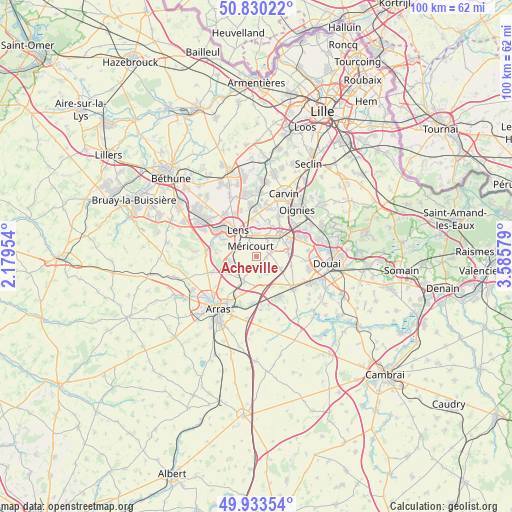
Acheville GPS coordinates[2]
50° 23' 2.4" North, 2° 52' 57.612" East
| Map corner | latitude | longitude |
|---|---|---|
| Upper-left | 50.83022°, | 2.17954° |
| Center: | 50.384°, | 2.88267° |
| Lower-right: | 49.93354°, | 3.58579° |
| Map W x H: | 99.7×99.7 km | = 62×62mi |
| max Lat: | 51.07786° ⇑3.7% North |
| Acheville: | 50.384° |
| min Lat: | ⇓96.3% South 41.3874° |
| min Long | Acheville | max Long |
| -5.08615° | 2.88267° | 9.52242° |
| W 56.2%⇐ | ⇒43.8% E |
Elevation
Elevation of Acheville is 58 m = 190 ft, and this is 135.7 m = 445 ft below average elevation for this country.
| Max E: |
2333 m = 7654 ft | 78.6% |
| Avg. | 193.7 m = 635 ft | |
| Acheville | 58 m = 190 ft | |
Min E: |
-1 m = -3 ft | 21.4% |
See also: France elevation on elevation.city.
Geographical zone
Acheville is located in North temperate zone (between Tropic of Cancer and the Arctic Circle). Distance of this North polar circle is 1799 km =1117.8 mi to North.| Distance of | km | miles | from Acheville |
|---|---|---|---|
| North Pole | 4404.9 | 2737.1 | to North |
| Arctic Circle | 1799 | 1117.8 | to North |
| Tropic Cancer | 2996.3 | 1861.8 | to South |
| Equator | 5602.2 | 3481 | to South |


Nearby cities:
15 places around Acheville: (largest is in red/bold)
• Arleux-en-Gohelle
2.4 km =1.5 mi,  198°
198°
• Avion
4.7 km =2.9 mi,  308°
308°
• Bailleul-Sir-Berthoult
5.6 km =3.5 mi, 203°
• Billy-Montigny
3.9 km =2.4 mi,  21°
21°
• Bois-Bernard
2.1 km =1.3 mi,  97°
97°
• Drocourt
3 km =1.9 mi,  77°
77°
• Farbus
5.1 km =3.2 mi,  233°
233°
• Fouquières-lès-Lens
5.4 km =3.4 mi, 23°
• Izel-lès-Équerchin
5.4 km =3.4 mi,  118°
118°
• Méricourt
2.4 km =1.5 mi,  323°
323°
• Noyelles-sous-Lens
5.3 km =3.3 mi,  351°
351°
• Rouvroy
1.8 km =1.1 mi,  58°
58°
• Sallaumines
4 km =2.5 mi,  338°
338°
• Vimy
5.3 km =3.3 mi,  255°
255°
• Willerval
4.1 km =2.5 mi,  221°
221°
Sources, notices
• [Note1] Compared only with cities in France existing in our database
• [Src1] Map data: © OpenStreetMap contributors (CC-BY-SA)
• [Src2] Other city data from geonames.org with taken over terms of usage.
• [Src3] Geographical zone / Annual Mean Temperature by Robert A. Rohde @ Wikipedia
