Maisons-Alfort geodata
Maisons-Alfort (Île-de-France) is a populated place; located in France in Europe/Paris (GMT+2) time zone. With population of 53,964 people, there are 102 cities with bigger population in this country. Compared to other cities in France, 75.7% of cities are located further ↓South; 50.4% of cities are located further →East and 85.9% of cities have higher elevation than Maisons-Alfort. Note1
Administrative division(s):
- Level 1: Île-de-France
- Level 2: Val-de-Marne
- Level 3: Arrondissement de Nogent-sur-Marne
- Level 4: Maisons-Alfort


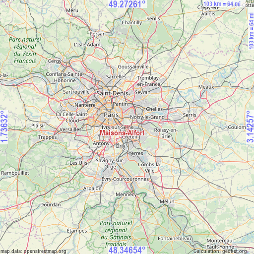
Maisons-Alfort GPS coordinates[2]
48° 48' 42.156" North, 2° 26' 22.02" East
| Map corner | latitude | longitude |
|---|---|---|
| Upper-left | 49.27261°, | 1.73632° |
| Center: | 48.81171°, | 2.43945° |
| Lower-right: | 48.34654°, | 3.14257° |
| Map W x H: | 103×103 km | = 64×64mi |
| max Lat: | 51.07786° ⇑24.3% North |
| Maisons-Alfort: | 48.81171° |
| min Lat: | ⇓75.7% South 41.3874° |
| min Long | Maisons-Alfort | max Long |
| -5.08615° | 2.43945° | 9.52242° |
| W 49.6%⇐ | ⇒50.4% E |
Elevation
Elevation of Maisons-Alfort is 40 m = 131 ft, and this is 153.7 m = 504 ft below average elevation for this country.
| Max E: |
2333 m = 7654 ft | 85.9% |
| Avg. | 193.7 m = 635 ft | |
| Maisons-Alfort | 40 m = 131 ft | |
Min E: |
-1 m = -3 ft | 14.1% |
See also: Maisons-Alfort elevation on elevation.city.
Geographical zone
Maisons-Alfort is located in North temperate zone (between Tropic of Cancer and the Arctic Circle). Distance of this North polar circle is 1973.8 km =1226.5 mi to North.| Distance of | km | miles | from Maisons-Alfort |
|---|---|---|---|
| North Pole | 4579.7 | 2845.7 | to North |
| Arctic Circle | 1973.8 | 1226.5 | to North |
| Tropic Cancer | 2821.4 | 1753.1 | to South |
| Equator | 5427.4 | 3372.4 | to South |


Nearby cities:
15 places around Maisons-Alfort: (largest is in red/bold)
• Alfortville
1.5 km =0.9 mi,  244°
244°
• Bonneuil-sur-Marne
5.5 km =3.4 mi,  148°
148°
• Champigny-sur-Marne
4 km =2.5 mi,  82°
82°
• Charenton-le-Pont
2.3 km =1.4 mi,  300°
300°
• Choisy-le-Roi
5 km =3.1 mi,  197°
197°
• Créteil
2.9 km =1.8 mi,  137°
137°
• Fontenay-sous-Bois
5.7 km =3.5 mi,  33°
33°
• Ivry-sur-Seine
4 km =2.5 mi,  276°
276°
• Joinville-le-Pont
3 km =1.9 mi,  59°
59°
• Nogent-sur-Marne
4.2 km =2.6 mi,  48°
48°
• Saint-Mandé
3.5 km =2.2 mi,  329°
329°
• Saint-Maur-des-Fossés
4.4 km =2.7 mi,  116°
116°
• Saint-Maurice
1.4 km =0.9 mi,  321°
321°
• Vincennes
4.1 km =2.5 mi,  358°
358°
• Vitry-sur-Seine
3.8 km =2.4 mi,  224°
224°
Sources, notices
• [Note1] Compared only with cities in France existing in our database
• [Src1] Map data: © OpenStreetMap contributors (CC-BY-SA)
• [Src2] Other city data from geonames.org with taken over terms of usage.
• [Src3] Geographical zone / Annual Mean Temperature by Robert A. Rohde @ Wikipedia
