Ivry-la-Bataille geodata
Ivry-la-Bataille (Normandy) is a populated place; located in France in Europe/Paris (GMT+2) time zone. With population of 2,661 people, there are 3668 cities with bigger population in this country. Compared to other cities in France, 77.2% of cities are located further ↓South; 63.5% of cities are located further →East and 75.8% of cities have higher elevation than Ivry-la-Bataille. Note1
Administrative division(s):
- Level 1: Normandy
- Level 2: Département de l'Eure
- Level 3: Arrondissement d’Évreux
- Level 4: Ivry-la-Bataille


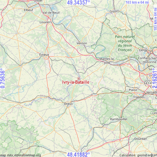
Ivry-la-Bataille GPS coordinates[2]
48° 52' 59.988" North, 1° 27' 34.128" East
| Map corner | latitude | longitude |
|---|---|---|
| Upper-left | 49.34357°, | 0.75636° |
| Center: | 48.88333°, | 1.45948° |
| Lower-right: | 48.41882°, | 2.16261° |
| Map W x H: | 102.8×102.8 km | = 63.9×63.9mi |
| max Lat: | 51.07786° ⇑22.8% North |
| Ivry-la-Bataille: | 48.88333° |
| min Lat: | ⇓77.2% South 41.3874° |
| min Long | Ivry-la-Bataill | max Long |
| -5.08615° | 1.45948° | 9.52242° |
| W 36.5%⇐ | ⇒63.5% E |
Elevation
Elevation of Ivry-la-Bataille is 65 m = 213 ft, and this is 128.7 m = 422 ft below average elevation for this country.
| Max E: |
2333 m = 7654 ft | 75.8% |
| Avg. | 193.7 m = 635 ft | |
| Ivry-la-Bataille | 65 m = 213 ft | |
Min E: |
-1 m = -3 ft | 24.2% |
See also: France elevation on elevation.city.
Geographical zone
Ivry-la-Bataille is located in North temperate zone (between Tropic of Cancer and the Arctic Circle). Distance of this North polar circle is 1965.9 km =1221.6 mi to North.| Distance of | km | miles | from Ivry-la-Bataille |
|---|---|---|---|
| North Pole | 4571.7 | 2840.7 | to North |
| Arctic Circle | 1965.9 | 1221.6 | to North |
| Tropic Cancer | 2829.4 | 1758.1 | to South |
| Equator | 5435.3 | 3377.3 | to South |


Nearby cities:
15 places around Ivry-la-Bataille: (largest is in red/bold)
• Anet
3.3 km =2.1 mi,  205°
205°
• Berchères-sur-Vesgre
7.7 km =4.8 mi,  126°
126°
• Bueil
5.5 km =3.4 mi,  347°
347°
• Croth
7.3 km =4.5 mi,  234°
234°
• Garennes-sur-Eure
3.5 km =2.2 mi,  333°
333°
• Gilles
5.2 km =3.2 mi,  51°
51°
• Guainville
4.4 km =2.7 mi,  31°
31°
• La Couture-Boussey
4.2 km =2.6 mi,  289°
289°
• Mouettes
7.3 km =4.5 mi,  281°
281°
• Neauphlette
7.2 km =4.5 mi,  42°
42°
• Oulins
2.2 km =1.4 mi,  159°
159°
• Rouvres
5.2 km =3.2 mi, 158°
• Saussay
4.8 km =3 mi, 230°
• Villiers-en-Désœuvre
8 km =5 mi,  21°
21°
• Ézy-sur-Eure
3.6 km =2.2 mi,  239°
239°
Sources, notices
• [Note1] Compared only with cities in France existing in our database
• [Src1] Map data: © OpenStreetMap contributors (CC-BY-SA)
• [Src2] Other city data from geonames.org with taken over terms of usage.
• [Src3] Geographical zone / Annual Mean Temperature by Robert A. Rohde @ Wikipedia
