Bueil geodata
Bueil (Normandy) is a populated place; located in France in Europe/Paris (GMT+2) time zone. With population of 1,480 people, there are 6248 cities with bigger population in this country. Compared to other cities in France, 78.2% of cities are located further ↓South; 63.7% of cities are located further →East and 71.9% of cities have higher elevation than Bueil. Note1
Administrative division(s):
- Level 1: Normandy
- Level 2: Département de l'Eure
- Level 3: Les Andelys
- Level 4: Bueil


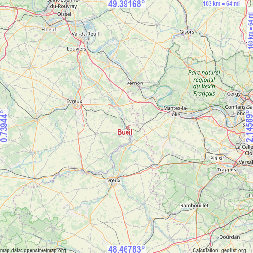
Bueil GPS coordinates[2]
48° 55' 54.804" North, 1° 26' 33.252" East
| Map corner | latitude | longitude |
|---|---|---|
| Upper-left | 49.39168°, | 0.73944° |
| Center: | 48.93189°, | 1.44257° |
| Lower-right: | 48.46783°, | 2.14569° |
| Map W x H: | 102.7×102.7 km | = 63.8×63.8mi |
| max Lat: | 51.07786° ⇑21.8% North |
| Bueil: | 48.93189° |
| min Lat: | ⇓78.2% South 41.3874° |
| min Long | Bueil | max Long |
| -5.08615° | 1.44257° | 9.52242° |
| W 36.3%⇐ | ⇒63.7% E |
Elevation
Elevation of Bueil is 74 m = 243 ft, and this is 119.7 m = 393 ft below average elevation for this country.
| Max E: |
2333 m = 7654 ft | 71.9% |
| Avg. | 193.7 m = 635 ft | |
| Bueil | 74 m = 243 ft | |
Min E: |
-1 m = -3 ft | 28.1% |
See also: France elevation on elevation.city.
Geographical zone
Bueil is located in North temperate zone (between Tropic of Cancer and the Arctic Circle). Distance of this North polar circle is 1960.5 km =1218.2 mi to North.| Distance of | km | miles | from Bueil |
|---|---|---|---|
| North Pole | 4566.3 | 2837.4 | to North |
| Arctic Circle | 1960.5 | 1218.2 | to North |
| Tropic Cancer | 2834.8 | 1761.5 | to South |
| Equator | 5440.7 | 3380.7 | to South |


Nearby cities:
15 places around Bueil: (largest is in red/bold)
• Anet
8.4 km =5.2 mi,  181°
181°
• Breuilpont
3.7 km =2.3 mi,  344°
344°
• Bréval
6.8 km =4.2 mi,  77°
77°
• Garennes-sur-Eure
2.3 km =1.4 mi,  187°
187°
• Gilles
5.7 km =3.5 mi,  112°
112°
• Guainville
3.9 km =2.4 mi,  115°
115°
• Ivry-la-Bataille
5.5 km =3.4 mi,  167°
167°
• La Couture-Boussey
4.9 km =3 mi,  214°
214°
• Lommoye
8.6 km =5.3 mi,  36°
36°
• Mouettes
7.2 km =4.5 mi,  236°
236°
• Mousseaux-Neuville
7.4 km =4.6 mi,  249°
249°
• Neauphlette
6.1 km =3.8 mi,  90°
90°
• Oulins
7.8 km =4.8 mi,  164°
164°
• Villiers-en-Désœuvre
4.7 km =2.9 mi,  64°
64°
• Ézy-sur-Eure
7.5 km =4.7 mi, 194°
Sources, notices
• [Note1] Compared only with cities in France existing in our database
• [Src1] Map data: © OpenStreetMap contributors (CC-BY-SA)
• [Src2] Other city data from geonames.org with taken over terms of usage.
• [Src3] Geographical zone / Annual Mean Temperature by Robert A. Rohde @ Wikipedia
