Hasparren geodata
Hasparren (Nouvelle-Aquitaine) is a populated place; located in France in Europe/Paris (GMT+2) time zone. With population of 6,250 people, there are 1589 cities with bigger population in this country. Compared to other cities in France, 94.4% of cities are located further ↑North; 90.8% of cities are located further →East and 65.6% of cities have higher elevation than Hasparren. Note1
Administrative division(s):
- Level 1: Nouvelle-Aquitaine
- Level 2: Département des Pyrénées-Atlantiques
- Level 3: Arrondissement de Bayonne
- Level 4: Hasparren


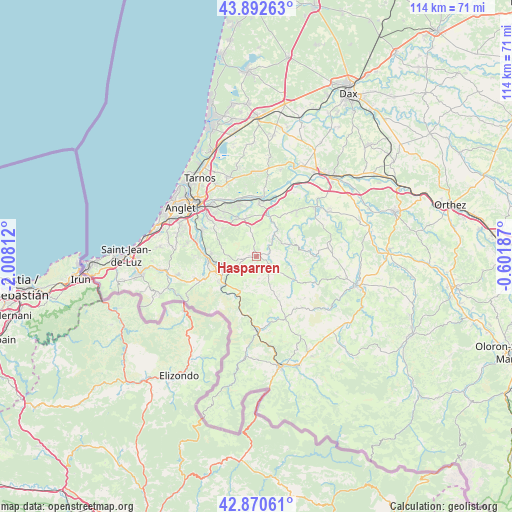
Hasparren GPS coordinates[2]
43° 23' 1.572" North, 1° 18' 17.964" West
| Map corner | latitude | longitude |
|---|---|---|
| Upper-left | 43.89263°, | -2.00812° |
| Center: | 43.38377°, | -1.30499° |
| Lower-right: | 42.87061°, | -0.60187° |
| Map W x H: | 113.6×113.6 km | = 70.6×70.6mi |
| max Lat: | 51.07786° ⇑94.4% North |
| Hasparren: | 43.38377° |
| min Lat: | ⇓5.6% South 41.3874° |
| min Long | Hasparren | max Long |
| -5.08615° | -1.30499° | 9.52242° |
| W 9.2%⇐ | ⇒90.8% E |
Elevation
Elevation of Hasparren is 88 m = 289 ft, and this is 105.7 m = 347 ft below average elevation for this country.
| Max E: |
2333 m = 7654 ft | 65.6% |
| Avg. | 193.7 m = 635 ft | |
| Hasparren | 88 m = 289 ft | |
Min E: |
-1 m = -3 ft | 34.4% |
See also: France elevation on elevation.city.
Geographical zone
Hasparren is located in North temperate zone (between Tropic of Cancer and the Arctic Circle). Distance of this Northern Tropic circle is 2217.9 km =1378.1 mi to South.| Distance of | km | miles | from Hasparren |
|---|---|---|---|
| North Pole | 5183.2 | 3220.7 | to North |
| Arctic Circle | 2577.4 | 1601.5 | to North |
| Tropic Cancer | 2217.9 | 1378.1 | to South |
| Equator | 4823.8 | 2997.4 | to South |


Nearby cities:
15 places around Hasparren: (largest is in red/bold)
• Ayherre
4.2 km =2.6 mi,  78°
78°
• Briscous
8.7 km =5.4 mi,  344°
344°
• Cambo-les-Bains
8.3 km =5.2 mi,  250°
250°
• Espelette
12.5 km =7.8 mi, 247°
• Halsou
9.7 km =6 mi,  265°
265°
• Hélette
9.8 km =6.1 mi,  149°
149°
• Itxassou
10.2 km =6.3 mi,  233°
233°
• Jatxou
10.2 km =6.3 mi, 272°
• Larressore
11 km =6.8 mi,  260°
260°
• Louhossoa
8.4 km =5.2 mi,  206°
206°
• Macaye
6 km =3.7 mi,  191°
191°
• Mendionde
4.9 km =3 mi,  175°
175°
• Urcuit
11.6 km =7.2 mi,  347°
347°
• Urt
11.8 km =7.3 mi,  2°
2°
• Ustaritz
12.3 km =7.6 mi,  276°
276°
Sources, notices
• [Note1] Compared only with cities in France existing in our database
• [Src1] Map data: © OpenStreetMap contributors (CC-BY-SA)
• [Src2] Other city data from geonames.org with taken over terms of usage.
• [Src3] Geographical zone / Annual Mean Temperature by Robert A. Rohde @ Wikipedia
