Hinx geodata
Hinx (Nouvelle-Aquitaine) is a populated place; located in France in Europe/Paris (GMT+2) time zone. With population of 1,204 people, there are 7509 cities with bigger population in this country. Compared to other cities in France, 90.4% of cities are located further ↑North; 87.5% of cities are located further →East and 81.8% of cities have higher elevation than Hinx. Note1
Administrative division(s):
- Level 1: Nouvelle-Aquitaine
- Level 2: Landes
- Level 3: Arrondissement de Dax
- Level 4: Hinx


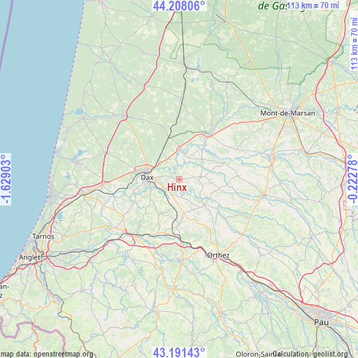
Hinx GPS coordinates[2]
43° 42' 6.84" North, 0° 55' 33.276" West
| Map corner | latitude | longitude |
|---|---|---|
| Upper-left | 44.20806°, | -1.62903° |
| Center: | 43.7019°, | -0.92591° |
| Lower-right: | 43.19143°, | -0.22278° |
| Map W x H: | 113×113 km | = 70.2×70.2mi |
| max Lat: | 51.07786° ⇑90.4% North |
| Hinx: | 43.7019° |
| min Lat: | ⇓9.6% South 41.3874° |
| min Long | Hinx | max Long |
| -5.08615° | -0.92591° | 9.52242° |
| W 12.5%⇐ | ⇒87.5% E |
Elevation
Elevation of Hinx is 50 m = 164 ft, and this is 143.7 m = 471 ft below average elevation for this country.
| Max E: |
2333 m = 7654 ft | 81.8% |
| Avg. | 193.7 m = 635 ft | |
| Hinx | 50 m = 164 ft | |
Min E: |
-1 m = -3 ft | 18.2% |
See also: France elevation on elevation.city.
Geographical zone
Hinx is located in North temperate zone (between Tropic of Cancer and the Arctic Circle). Distance of this Northern Tropic circle is 2253.3 km =1400.1 mi to South.| Distance of | km | miles | from Hinx |
|---|---|---|---|
| North Pole | 5147.9 | 3198.8 | to North |
| Arctic Circle | 2542 | 1579.5 | to North |
| Tropic Cancer | 2253.3 | 1400.1 | to South |
| Equator | 4859.2 | 3019.4 | to South |


Nearby cities:
15 places around Hinx: (largest is in red/bold)
• Candresse
4.4 km =2.7 mi,  287°
287°
• Castelnau-Chalosse
7.9 km =4.9 mi,  122°
122°
• Clermont
5.6 km =3.5 mi,  172°
172°
• Dax
10.3 km =6.4 mi,  275°
275°
• Gamarde-les-Bains
5.5 km =3.4 mi,  51°
51°
• Mimbaste
7 km =4.3 mi,  213°
213°
• Montfort-en-Chalosse
7 km =4.3 mi,  81°
81°
• Narrosse
6.6 km =4.1 mi,  271°
271°
• Pontonx-sur-l'Adour
9.6 km =6 mi,  0°
0°
• Poyartin
5 km =3.1 mi,  110°
110°
• Saint-Pandelon
9.8 km =6.1 mi,  249°
249°
• Saint-Paul-lès-Dax
10.5 km =6.5 mi, 285°
• Saint-Vincent-de-Paul
8 km =5 mi,  306°
306°
• Saugnac-et-Cambran
6.5 km =4 mi,  238°
238°
• Sort-en-Chalosse
2.1 km =1.3 mi,  193°
193°
Sources, notices
• [Note1] Compared only with cities in France existing in our database
• [Src1] Map data: © OpenStreetMap contributors (CC-BY-SA)
• [Src2] Other city data from geonames.org with taken over terms of usage.
• [Src3] Geographical zone / Annual Mean Temperature by Robert A. Rohde @ Wikipedia
