Mimbaste geodata
Mimbaste (Nouvelle-Aquitaine) is a populated place; located in France in Europe/Paris (GMT+2) time zone. With population of 1,089 people, there are 8201 cities with bigger population in this country. Compared to other cities in France, 91.2% of cities are located further ↑North; 88% of cities are located further →East and 95% of cities have higher elevation than Mimbaste. Note1
Administrative division(s):
- Level 1: Nouvelle-Aquitaine
- Level 2: Landes
- Level 3: Arrondissement de Dax
- Level 4: Mimbaste


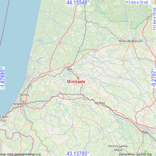
Mimbaste GPS coordinates[2]
43° 38' 55.932" North, 0° 58' 25.788" West
| Map corner | latitude | longitude |
|---|---|---|
| Upper-left | 44.15548°, | -1.67695° |
| Center: | 43.64887°, | -0.97383° |
| Lower-right: | 43.13795°, | -0.2707° |
| Map W x H: | 113.1×113.1 km | = 70.3×70.3mi |
| max Lat: | 51.07786° ⇑91.2% North |
| Mimbaste: | 43.64887° |
| min Lat: | ⇓8.8% South 41.3874° |
| min Long | Mimbaste | max Long |
| -5.08615° | -0.97383° | 9.52242° |
| W 12%⇐ | ⇒88% E |
Elevation
Elevation of Mimbaste is 17 m = 56 ft, and this is 176.7 m = 580 ft below average elevation for this country.
| Max E: |
2333 m = 7654 ft | 95% |
| Avg. | 193.7 m = 635 ft | |
| Mimbaste | 17 m = 56 ft | |
Min E: |
-1 m = -3 ft | 5% |
See also: France elevation on elevation.city.
Geographical zone
Mimbaste is located in North temperate zone (between Tropic of Cancer and the Arctic Circle). Distance of this Northern Tropic circle is 2247.4 km =1396.5 mi to South.| Distance of | km | miles | from Mimbaste |
|---|---|---|---|
| North Pole | 5153.8 | 3202.4 | to North |
| Arctic Circle | 2547.9 | 1583.2 | to North |
| Tropic Cancer | 2247.4 | 1396.5 | to South |
| Equator | 4853.3 | 3015.7 | to South |


Nearby cities:
15 places around Mimbaste: (largest is in red/bold)
• Candresse
7.2 km =4.5 mi,  357°
357°
• Clermont
4.6 km =2.9 mi,  86°
86°
• Dax
9.4 km =5.8 mi,  316°
316°
• Estibeaux
7.6 km =4.7 mi,  135°
135°
• Habas
9.3 km =5.8 mi,  157°
157°
• Heugas
8.7 km =5.4 mi,  265°
265°
• Hinx
7 km =4.3 mi,  33°
33°
• Misson
6.4 km =4 mi,  169°
169°
• Narrosse
6.7 km =4.2 mi,  336°
336°
• Oeyreluy
9 km =5.6 mi,  284°
284°
• Pouillon
5.3 km =3.3 mi,  202°
202°
• Saint-Pandelon
5.8 km =3.6 mi,  294°
294°
• Saugnac-et-Cambran
3 km =1.9 mi,  325°
325°
• Seyresse
8 km =5 mi,  297°
297°
• Sort-en-Chalosse
5.1 km =3.2 mi,  40°
40°
Sources, notices
• [Note1] Compared only with cities in France existing in our database
• [Src1] Map data: © OpenStreetMap contributors (CC-BY-SA)
• [Src2] Other city data from geonames.org with taken over terms of usage.
• [Src3] Geographical zone / Annual Mean Temperature by Robert A. Rohde @ Wikipedia
