Narrosse geodata
Narrosse (Nouvelle-Aquitaine) is a populated place; located in France in Europe/Paris (GMT+2) time zone. With population of 2,781 people, there are 3518 cities with bigger population in this country. Compared to other cities in France, 90.3% of cities are located further ↑North; 88.2% of cities are located further →East and 96% of cities have higher elevation than Narrosse. Note1
Administrative division(s):
- Level 1: Nouvelle-Aquitaine
- Level 2: Landes
- Level 3: Arrondissement de Dax
- Level 4: Narrosse


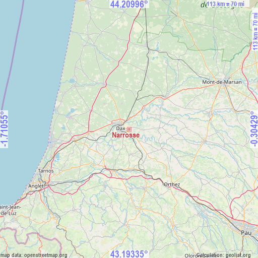
Narrosse GPS coordinates[2]
43° 42' 13.716" North, 1° 0' 26.712" West
| Map corner | latitude | longitude |
|---|---|---|
| Upper-left | 44.20996°, | -1.71055° |
| Center: | 43.70381°, | -1.00742° |
| Lower-right: | 43.19335°, | -0.30429° |
| Map W x H: | 113×113 km | = 70.2×70.2mi |
| max Lat: | 51.07786° ⇑90.3% North |
| Narrosse: | 43.70381° |
| min Lat: | ⇓9.7% South 41.3874° |
| min Long | Narrosse | max Long |
| -5.08615° | -1.00742° | 9.52242° |
| W 11.8%⇐ | ⇒88.2% E |
Elevation
Elevation of Narrosse is 14 m = 46 ft, and this is 179.7 m = 590 ft below average elevation for this country.
| Max E: |
2333 m = 7654 ft | 96% |
| Avg. | 193.7 m = 635 ft | |
| Narrosse | 14 m = 46 ft | |
Min E: |
-1 m = -3 ft | 4% |
See also: France elevation on elevation.city.
Geographical zone
Narrosse is located in North temperate zone (between Tropic of Cancer and the Arctic Circle). Distance of this Northern Tropic circle is 2253.5 km =1400.3 mi to South.| Distance of | km | miles | from Narrosse |
|---|---|---|---|
| North Pole | 5147.7 | 3198.6 | to North |
| Arctic Circle | 2541.8 | 1579.4 | to North |
| Tropic Cancer | 2253.5 | 1400.3 | to South |
| Equator | 4859.4 | 3019.5 | to South |


Nearby cities:
15 places around Narrosse: (largest is in red/bold)
• Candresse
2.6 km =1.6 mi,  65°
65°
• Clermont
9.3 km =5.8 mi,  128°
128°
• Dax
3.8 km =2.4 mi,  281°
281°
• Heugas
9 km =5.6 mi,  221°
221°
• Hinx
6.6 km =4.1 mi,  91°
91°
• Mimbaste
6.7 km =4.2 mi,  156°
156°
• Mées
8.2 km =5.1 mi,  270°
270°
• Oeyreluy
7.2 km =4.5 mi,  237°
237°
• Saint-Pandelon
4.5 km =2.8 mi,  214°
214°
• Saint-Paul-lès-Dax
4.4 km =2.7 mi,  306°
306°
• Saint-Vincent-de-Paul
4.5 km =2.8 mi,  0°
0°
• Saugnac-et-Cambran
3.8 km =2.4 mi, 164°
• Seyresse
5 km =3.1 mi, 241°
• Sort-en-Chalosse
6.5 km =4 mi,  110°
110°
• Tercis-les-Bains
8.9 km =5.5 mi,  245°
245°
Sources, notices
• [Note1] Compared only with cities in France existing in our database
• [Src1] Map data: © OpenStreetMap contributors (CC-BY-SA)
• [Src2] Other city data from geonames.org with taken over terms of usage.
• [Src3] Geographical zone / Annual Mean Temperature by Robert A. Rohde @ Wikipedia
