Candresse geodata
Candresse (Nouvelle-Aquitaine) is a populated place; located in France in Europe/Paris (GMT+2) time zone. With population of 622 people, there are 12950 cities with bigger population in this country. Compared to other cities in France, 90.2% of cities are located further ↑North; 88% of cities are located further →East and 93.6% of cities have higher elevation than Candresse. Note1
Administrative division(s):
- Level 1: Nouvelle-Aquitaine
- Level 2: Landes
- Level 3: Arrondissement de Dax
- Level 4: Candresse


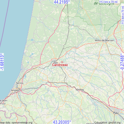
Candresse GPS coordinates[2]
43° 42' 48.348" North, 0° 58' 40.8" West
| Map corner | latitude | longitude |
|---|---|---|
| Upper-left | 44.2195°, | -1.68113° |
| Center: | 43.71343°, | -0.978° |
| Lower-right: | 43.20305°, | -0.27488° |
| Map W x H: | 113×113 km | = 70.2×70.2mi |
| max Lat: | 51.07786° ⇑90.2% North |
| Candresse: | 43.71343° |
| min Lat: | ⇓9.8% South 41.3874° |
| min Long | Candresse | max Long |
| -5.08615° | -0.978° | 9.52242° |
| W 12%⇐ | ⇒88% E |
Elevation
Elevation of Candresse is 21 m = 69 ft, and this is 172.7 m = 567 ft below average elevation for this country.
| Max E: |
2333 m = 7654 ft | 93.6% |
| Avg. | 193.7 m = 635 ft | |
| Candresse | 21 m = 69 ft | |
Min E: |
-1 m = -3 ft | 6.4% |
See also: France elevation on elevation.city.
Geographical zone
Candresse is located in North temperate zone (between Tropic of Cancer and the Arctic Circle). Distance of this Northern Tropic circle is 2254.6 km =1400.9 mi to South.| Distance of | km | miles | from Candresse |
|---|---|---|---|
| North Pole | 5146.6 | 3197.9 | to North |
| Arctic Circle | 2540.7 | 1578.7 | to North |
| Tropic Cancer | 2254.6 | 1400.9 | to South |
| Equator | 4860.5 | 3020.2 | to South |


Nearby cities:
15 places around Candresse: (largest is in red/bold)
• Clermont
8.4 km =5.2 mi,  144°
144°
• Dax
6.1 km =3.8 mi,  266°
266°
• Gamarde-les-Bains
8.7 km =5.4 mi,  75°
75°
• Hinx
4.4 km =2.7 mi,  107°
107°
• Mimbaste
7.2 km =4.5 mi,  177°
177°
• Narrosse
2.6 km =1.6 mi,  245°
245°
• Oeyreluy
9.8 km =6.1 mi,  239°
239°
• Pontonx-sur-l'Adour
9.3 km =5.8 mi,  27°
27°
• Poyartin
9.4 km =5.8 mi, 108°
• Saint-Pandelon
6.9 km =4.3 mi,  225°
225°
• Saint-Paul-lès-Dax
6.1 km =3.8 mi,  284°
284°
• Saint-Vincent-de-Paul
4.1 km =2.5 mi,  326°
326°
• Saugnac-et-Cambran
4.9 km =3 mi,  196°
196°
• Seyresse
7.6 km =4.7 mi, 242°
• Sort-en-Chalosse
4.9 km =3 mi,  131°
131°
Sources, notices
• [Note1] Compared only with cities in France existing in our database
• [Src1] Map data: © OpenStreetMap contributors (CC-BY-SA)
• [Src2] Other city data from geonames.org with taken over terms of usage.
• [Src3] Geographical zone / Annual Mean Temperature by Robert A. Rohde @ Wikipedia
