Dax geodata
Dax (Nouvelle-Aquitaine) is a seat of a third-order administrative division; located in France in Europe/Paris (GMT+2) time zone. With population of 22,305 people, there are 403 cities with bigger population in this country. Compared to other cities in France, 90.3% of cities are located further ↑North; 88.7% of cities are located further →East and 95.4% of cities have higher elevation than Dax. Note1
Administrative division(s):
- Level 1: Nouvelle-Aquitaine
- Level 2: Landes
- Level 3: Arrondissement de Dax
- Level 4: Dax


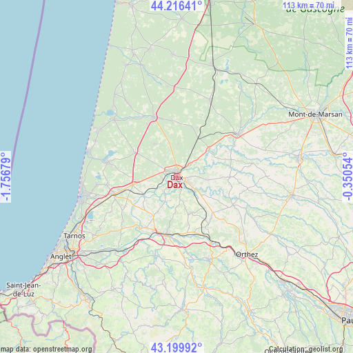
Dax GPS coordinates[2]
43° 42' 37.152" North, 1° 3' 13.176" West
| Map corner | latitude | longitude |
|---|---|---|
| Upper-left | 44.21641°, | -1.75679° |
| Center: | 43.71032°, | -1.05366° |
| Lower-right: | 43.19992°, | -0.35054° |
| Map W x H: | 113×113 km | = 70.2×70.2mi |
| max Lat: | 51.07786° ⇑90.3% North |
| Dax: | 43.71032° |
| min Lat: | ⇓9.7% South 41.3874° |
| min Long | Dax | max Long |
| -5.08615° | -1.05366° | 9.52242° |
| W 11.3%⇐ | ⇒88.7% E |
Elevation
Elevation of Dax is 16 m = 52 ft, and this is 177.7 m = 583 ft below average elevation for this country.
| Max E: |
2333 m = 7654 ft | 95.4% |
| Avg. | 193.7 m = 635 ft | |
| Dax | 16 m = 52 ft | |
Min E: |
-1 m = -3 ft | 4.6% |
See also: France elevation on elevation.city.
Geographical zone
Dax is located in North temperate zone (between Tropic of Cancer and the Arctic Circle). Distance of this Northern Tropic circle is 2254.2 km =1400.7 mi to South.| Distance of | km | miles | from Dax |
|---|---|---|---|
| North Pole | 5146.9 | 3198.1 | to North |
| Arctic Circle | 2541 | 1578.9 | to North |
| Tropic Cancer | 2254.2 | 1400.7 | to South |
| Equator | 4860.1 | 3019.9 | to South |


Nearby cities:
15 places around Dax: (largest is in red/bold)
• Candresse
6.1 km =3.8 mi,  86°
86°
• Heugas
7.8 km =4.8 mi,  196°
196°
• Hinx
10.3 km =6.4 mi,  95°
95°
• Mimbaste
9.4 km =5.8 mi,  136°
136°
• Mées
4.5 km =2.8 mi,  261°
261°
• Narrosse
3.8 km =2.4 mi, 101°
• Oeyreluy
5.2 km =3.2 mi,  206°
206°
• Rivière-Saas-et-Gourby
8.4 km =5.2 mi,  246°
246°
• Saint-Pandelon
4.6 km =2.9 mi,  165°
165°
• Saint-Paul-lès-Dax
1.9 km =1.2 mi,  5°
5°
• Saint-Vincent-de-Paul
5.3 km =3.3 mi,  45°
45°
• Saugnac-et-Cambran
6.4 km =4 mi,  132°
132°
• Seyresse
3.2 km =2 mi,  192°
192°
• Sort-en-Chalosse
10.2 km =6.3 mi,  106°
106°
• Tercis-les-Bains
6.2 km =3.9 mi,  224°
224°
Sources, notices
• [Note1] Compared only with cities in France existing in our database
• [Src1] Map data: © OpenStreetMap contributors (CC-BY-SA)
• [Src2] Other city data from geonames.org with taken over terms of usage.
• [Src3] Geographical zone / Annual Mean Temperature by Robert A. Rohde @ Wikipedia
