Hersin-Coupigny geodata
Hersin-Coupigny (Hauts-de-France) is a populated place; located in France in Europe/Paris (GMT+2) time zone. With population of 6,609 people, there are 1492 cities with bigger population in this country. Compared to other cities in France, 96.8% of cities are located further ↓South; 52.7% of cities are located further ←West and 71.9% of cities have higher elevation than Hersin-Coupigny. Note1
Administrative division(s):
- Level 1: Hauts-de-France
- Level 2: Pas-de-Calais
- Level 3: Arrondissement de Béthune
- Level 4: Hersin-Coupigny


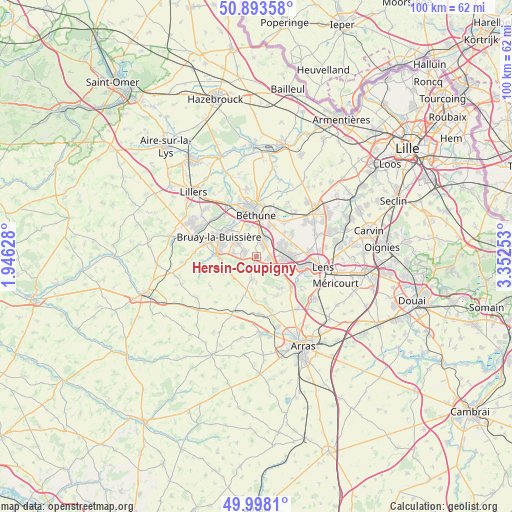
Hersin-Coupigny GPS coordinates[2]
50° 26' 52.656" North, 2° 38' 57.84" East
| Map corner | latitude | longitude |
|---|---|---|
| Upper-left | 50.89358°, | 1.94628° |
| Center: | 50.44796°, | 2.6494° |
| Lower-right: | 49.9981°, | 3.35253° |
| Map W x H: | 99.6×99.6 km | = 61.9×61.9mi |
| max Lat: | 51.07786° ⇑3.2% North |
| Hersin-Coupigny: | 50.44796° |
| min Lat: | ⇓96.8% South 41.3874° |
| min Long | Hersin-Coupigny | max Long |
| -5.08615° | 2.6494° | 9.52242° |
| W 52.7%⇐ | ⇒47.3% E |
Elevation
Elevation of Hersin-Coupigny is 74 m = 243 ft, and this is 119.7 m = 393 ft below average elevation for this country.
| Max E: |
2333 m = 7654 ft | 71.9% |
| Avg. | 193.7 m = 635 ft | |
| Hersin-Coupigny | 74 m = 243 ft | |
Min E: |
-1 m = -3 ft | 28.1% |
See also: France elevation on elevation.city.
Geographical zone
Hersin-Coupigny is located in North temperate zone (between Tropic of Cancer and the Arctic Circle). Distance of this North polar circle is 1791.9 km =1113.4 mi to North.| Distance of | km | miles | from Hersin-Coupigny |
|---|---|---|---|
| North Pole | 4397.8 | 2732.7 | to North |
| Arctic Circle | 1791.9 | 1113.4 | to North |
| Tropic Cancer | 3003.4 | 1866.2 | to South |
| Equator | 5609.3 | 3485.5 | to South |


Nearby cities:
15 places around Hersin-Coupigny: (largest is in red/bold)
• Aix-Noulette
4.7 km =2.9 mi,  121°
121°
• Barlin
2.2 km =1.4 mi,  283°
283°
• Bouvigny-Boyeffles
3.4 km =2.1 mi,  151°
151°
• Bully-les-Mines
5.5 km =3.4 mi,  94°
94°
• Fresnicourt-le-Dolmen
4.8 km =3 mi,  226°
226°
• Haillicourt
6.1 km =3.8 mi,  299°
299°
• Houchin
4.4 km =2.7 mi,  331°
331°
• Labourse
6.1 km =3.8 mi,  21°
21°
• Maisnil-lès-Ruitz
4.3 km =2.7 mi, 278°
• Mazingarbe
5.3 km =3.3 mi,  61°
61°
• Nœux-les-Mines
4.1 km =2.5 mi, 17°
• Ruitz
4.8 km =3 mi, 295°
• Sains-en-Gohelle
2.4 km =1.5 mi,  97°
97°
• Servins
4.3 km =2.7 mi,  194°
194°
• Vaudricourt
6.1 km =3.8 mi,  343°
343°
Sources, notices
• [Note1] Compared only with cities in France existing in our database
• [Src1] Map data: © OpenStreetMap contributors (CC-BY-SA)
• [Src2] Other city data from geonames.org with taken over terms of usage.
• [Src3] Geographical zone / Annual Mean Temperature by Robert A. Rohde @ Wikipedia
