Ruitz geodata
Ruitz (Hauts-de-France) is a populated place; located in France in Europe/Paris (GMT+2) time zone. With population of 1,622 people, there are 5756 cities with bigger population in this country. Compared to other cities in France, 97% of cities are located further ↓South; 51.9% of cities are located further ←West and 78.2% of cities have higher elevation than Ruitz. Note1
Administrative division(s):
- Level 1: Hauts-de-France
- Level 2: Pas-de-Calais
- Level 3: Arrondissement de Béthune
- Level 4: Ruitz


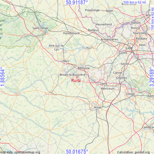
Ruitz GPS coordinates[2]
50° 27' 59.148" North, 2° 35' 19.536" East
| Map corner | latitude | longitude |
|---|---|---|
| Upper-left | 50.91187°, | 1.88564° |
| Center: | 50.46643°, | 2.58876° |
| Lower-right: | 50.01675°, | 3.29189° |
| Map W x H: | 99.5×99.5 km | = 61.8×61.8mi |
| max Lat: | 51.07786° ⇑3% North |
| Ruitz: | 50.46643° |
| min Lat: | ⇓97% South 41.3874° |
| min Long | Ruitz | max Long |
| -5.08615° | 2.58876° | 9.52242° |
| W 51.9%⇐ | ⇒48.1% E |
Elevation
Elevation of Ruitz is 59 m = 194 ft, and this is 134.7 m = 442 ft below average elevation for this country.
| Max E: |
2333 m = 7654 ft | 78.2% |
| Avg. | 193.7 m = 635 ft | |
| Ruitz | 59 m = 194 ft | |
Min E: |
-1 m = -3 ft | 21.8% |
See also: France elevation on elevation.city.
Geographical zone
Ruitz is located in North temperate zone (between Tropic of Cancer and the Arctic Circle). Distance of this North polar circle is 1789.8 km =1112.1 mi to North.| Distance of | km | miles | from Ruitz |
|---|---|---|---|
| North Pole | 4395.7 | 2731.4 | to North |
| Arctic Circle | 1789.8 | 1112.1 | to North |
| Tropic Cancer | 3005.4 | 1867.5 | to South |
| Equator | 5611.3 | 3486.7 | to South |


Nearby cities:
15 places around Ruitz: (largest is in red/bold)
• Barlin
2.7 km =1.7 mi,  125°
125°
• Bruay-la-Buissière
3.3 km =2.1 mi,  304°
304°
• Fouquières-lès-Béthune
5.6 km =3.5 mi,  15°
15°
• Fresnicourt-le-Dolmen
5.4 km =3.4 mi,  171°
171°
• Gosnay
4.4 km =2.7 mi,  0°
0°
• Haillicourt
1.4 km =0.9 mi,  314°
314°
• Hersin-Coupigny
4.8 km =3 mi,  115°
115°
• Hesdigneul-lès-Béthune
3.9 km =2.4 mi, 0°
• Houchin
2.8 km =1.7 mi,  50°
50°
• Houdain
4 km =2.5 mi,  243°
243°
• Maisnil-lès-Ruitz
1.4 km =0.9 mi,  176°
176°
• Nœux-les-Mines
5.8 km =3.6 mi,  71°
71°
• Ranchicourt
4.1 km =2.5 mi,  213°
213°
• Vaudricourt
4.6 km =2.9 mi,  33°
33°
• Verquin
5.3 km =3.3 mi,  41°
41°
Sources, notices
• [Note1] Compared only with cities in France existing in our database
• [Src1] Map data: © OpenStreetMap contributors (CC-BY-SA)
• [Src2] Other city data from geonames.org with taken over terms of usage.
• [Src3] Geographical zone / Annual Mean Temperature by Robert A. Rohde @ Wikipedia
