Vaudricourt geodata
Vaudricourt (Hauts-de-France) is a populated place; located in France in Europe/Paris (GMT+2) time zone. With population of 945 people, there are 9241 cities with bigger population in this country. Compared to other cities in France, 97.3% of cities are located further ↓South; 52.4% of cities are located further ←West and 84.5% of cities have higher elevation than Vaudricourt. Note1
Administrative division(s):
- Level 1: Hauts-de-France
- Level 2: Pas-de-Calais
- Level 3: Arrondissement de Béthune
- Level 4: Vaudricourt


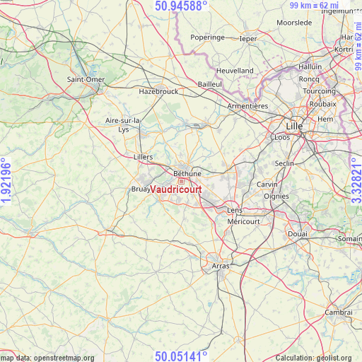
Vaudricourt GPS coordinates[2]
50° 30' 2.736" North, 2° 37' 30.324" East
| Map corner | latitude | longitude |
|---|---|---|
| Upper-left | 50.94588°, | 1.92196° |
| Center: | 50.50076°, | 2.62509° |
| Lower-right: | 50.05141°, | 3.32821° |
| Map W x H: | 99.5×99.5 km | = 61.8×61.8mi |
| max Lat: | 51.07786° ⇑2.7% North |
| Vaudricourt: | 50.50076° |
| min Lat: | ⇓97.3% South 41.3874° |
| min Long | Vaudricourt | max Long |
| -5.08615° | 2.62509° | 9.52242° |
| W 52.4%⇐ | ⇒47.6% E |
Elevation
Elevation of Vaudricourt is 43 m = 141 ft, and this is 150.7 m = 494 ft below average elevation for this country.
| Max E: |
2333 m = 7654 ft | 84.5% |
| Avg. | 193.7 m = 635 ft | |
| Vaudricourt | 43 m = 141 ft | |
Min E: |
-1 m = -3 ft | 15.5% |
See also: France elevation on elevation.city.
Geographical zone
Vaudricourt is located in North temperate zone (between Tropic of Cancer and the Arctic Circle). Distance of this North polar circle is 1786 km =1109.8 mi to North.| Distance of | km | miles | from Vaudricourt |
|---|---|---|---|
| North Pole | 4391.9 | 2729 | to North |
| Arctic Circle | 1786 | 1109.8 | to North |
| Tropic Cancer | 3009.2 | 1869.8 | to South |
| Equator | 5615.2 | 3489.1 | to South |


Nearby cities:
15 places around Vaudricourt: (largest is in red/bold)
• Annezin
3.5 km =2.2 mi,  351°
351°
• Beuvry
4.6 km =2.9 mi,  67°
67°
• Béthune
3.4 km =2.1 mi,  18°
18°
• Fouquereuil
2.7 km =1.7 mi,  318°
318°
• Fouquières-lès-Béthune
1.9 km =1.2 mi,  326°
326°
• Gosnay
2.6 km =1.6 mi,  283°
283°
• Haillicourt
4.6 km =2.9 mi,  231°
231°
• Hesdigneul-lès-Béthune
2.5 km =1.6 mi,  272°
272°
• Houchin
2.1 km =1.3 mi,  190°
190°
• Labeuvrière
4.9 km =3 mi,  294°
294°
• Labourse
4 km =2.5 mi,  93°
93°
• Nœux-les-Mines
3.5 km =2.2 mi,  123°
123°
• Ruitz
4.6 km =2.9 mi,  213°
213°
• Vendin-lès-Béthune
4.7 km =2.9 mi,  338°
338°
• Verquin
1 km =0.6 mi,  79°
79°
Sources, notices
• [Note1] Compared only with cities in France existing in our database
• [Src1] Map data: © OpenStreetMap contributors (CC-BY-SA)
• [Src2] Other city data from geonames.org with taken over terms of usage.
• [Src3] Geographical zone / Annual Mean Temperature by Robert A. Rohde @ Wikipedia
