Mazingarbe geodata
Mazingarbe (Hauts-de-France) is a populated place; located in France in Europe/Paris (GMT+2) time zone. With population of 7,587 people, there are 1280 cities with bigger population in this country. Compared to other cities in France, 97% of cities are located further ↓South; 53.7% of cities are located further ←West and 86.7% of cities have higher elevation than Mazingarbe. Note1
Administrative division(s):
- Level 1: Hauts-de-France
- Level 2: Pas-de-Calais
- Level 3: Arrondissement de Lens
- Level 4: Mazingarbe


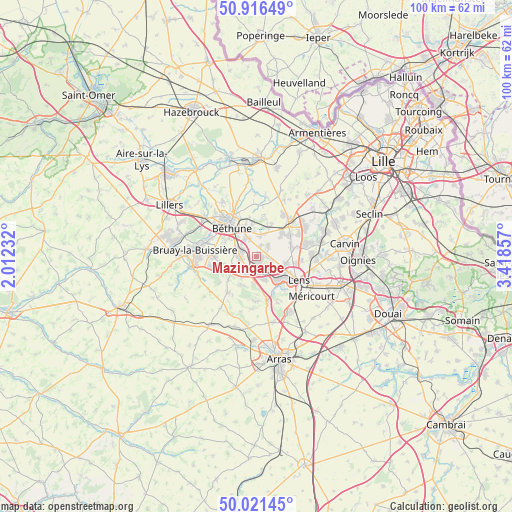
Mazingarbe GPS coordinates[2]
50° 28' 15.924" North, 2° 42' 55.584" East
| Map corner | latitude | longitude |
|---|---|---|
| Upper-left | 50.91649°, | 2.01232° |
| Center: | 50.47109°, | 2.71544° |
| Lower-right: | 50.02145°, | 3.41857° |
| Map W x H: | 99.5×99.5 km | = 61.8×61.8mi |
| max Lat: | 51.07786° ⇑3% North |
| Mazingarbe: | 50.47109° |
| min Lat: | ⇓97% South 41.3874° |
| min Long | Mazingarbe | max Long |
| -5.08615° | 2.71544° | 9.52242° |
| W 53.7%⇐ | ⇒46.3% E |
Elevation
Elevation of Mazingarbe is 38 m = 125 ft, and this is 155.7 m = 511 ft below average elevation for this country.
| Max E: |
2333 m = 7654 ft | 86.7% |
| Avg. | 193.7 m = 635 ft | |
| Mazingarbe | 38 m = 125 ft | |
Min E: |
-1 m = -3 ft | 13.3% |
See also: France elevation on elevation.city.
Geographical zone
Mazingarbe is located in North temperate zone (between Tropic of Cancer and the Arctic Circle). Distance of this North polar circle is 1789.3 km =1111.8 mi to North.| Distance of | km | miles | from Mazingarbe |
|---|---|---|---|
| North Pole | 4395.2 | 2731 | to North |
| Arctic Circle | 1789.3 | 1111.8 | to North |
| Tropic Cancer | 3005.9 | 1867.8 | to South |
| Equator | 5611.9 | 3487.1 | to South |


Nearby cities:
15 places around Mazingarbe: (largest is in red/bold)
• Aix-Noulette
5.1 km =3.2 mi,  187°
187°
• Annequin
3.8 km =2.4 mi,  5°
5°
• Beuvry
5.5 km =3.4 mi,  337°
337°
• Bully-les-Mines
3.1 km =1.9 mi,  164°
164°
• Cambrin
4.7 km =2.9 mi,  22°
22°
• Cuinchy
5.7 km =3.5 mi, 24°
• Grenay
3.5 km =2.2 mi,  132°
132°
• Hersin-Coupigny
5.3 km =3.3 mi,  241°
241°
• Labourse
3.9 km =2.4 mi,  321°
321°
• Loos-en-Gohelle
5.6 km =3.5 mi,  105°
105°
• Noyelles-lès-Vermelles
2.2 km =1.4 mi, 20°
• Nœux-les-Mines
3.7 km =2.3 mi,  291°
291°
• Sailly-Labourse
3.6 km =2.2 mi, 338°
• Sains-en-Gohelle
3.7 km =2.3 mi,  218°
218°
• Vermelles
3 km =1.9 mi,  47°
47°
Sources, notices
• [Note1] Compared only with cities in France existing in our database
• [Src1] Map data: © OpenStreetMap contributors (CC-BY-SA)
• [Src2] Other city data from geonames.org with taken over terms of usage.
• [Src3] Geographical zone / Annual Mean Temperature by Robert A. Rohde @ Wikipedia
