Hauteville-Lompnes geodata
Hauteville-Lompnes (Auvergne-Rhône-Alpes) is a populated place; located in France in Europe/Paris (GMT+2) time zone. With population of 4,096 people, there are 2397 cities with bigger population in this country. Compared to other cities in France, 66.5% of cities are located further ↑North; 83.7% of cities are located further ←West and 97.9% of cities have lower elevation than Hauteville-Lompnes. Note1
Administrative division(s):
- Level 1: Auvergne-Rhône-Alpes
- Level 2: Département de l'Ain
- Level 3: Arrondissement de Belley
- Level 4: Plateau d'Hauteville


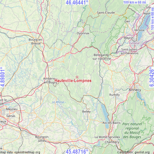
Hauteville-Lompnes GPS coordinates[2]
45° 58' 40.584" North, 5° 36' 4.104" East
| Map corner | latitude | longitude |
|---|---|---|
| Upper-left | 46.46441°, | 4.89801° |
| Center: | 45.97794°, | 5.60114° |
| Lower-right: | 45.48716°, | 6.30426° |
| Map W x H: | 108.7×108.7 km | = 67.5×67.5mi |
| max Lat: | 51.07786° ⇑66.5% North |
| Hauteville-Lompnes: | 45.97794° |
| min Lat: | ⇓33.5% South 41.3874° |
| min Long | Hauteville-Lomp | max Long |
| -5.08615° | 5.60114° | 9.52242° |
| W 83.7%⇐ | ⇒16.3% E |
Elevation
Elevation of Hauteville-Lompnes is 804 m = 2638 ft, and this is 610.3 m = 2002 ft above average elevation for this country.
| Max E: |
2333 m = 7654 ft | 2.1% |
| Hauteville-Lompnes | 804 m 2638 ft | |
| Avg. | 193.7 m = 635 ft | |
Min E: |
-1 m = -3 ft | 97.9% |
See also: France elevation on elevation.city.
Geographical zone
Hauteville-Lompnes is located in North temperate zone (between Tropic of Cancer and the Arctic Circle). Distance of this North polar circle is 2288.9 km =1422.3 mi to North.| Distance of | km | miles | from Hauteville-Lompnes |
|---|---|---|---|
| North Pole | 4894.8 | 3041.5 | to North |
| Arctic Circle | 2288.9 | 1422.3 | to North |
| Tropic Cancer | 2506.3 | 1557.3 | to South |
| Equator | 5112.3 | 3176.6 | to South |


Nearby cities:
15 places around Hauteville-Lompnes: (largest is in red/bold)
• Anglefort
17.7 km =11 mi,  114°
114°
• Artemare
13.6 km =8.5 mi,  148°
148°
• Cerdon
15.5 km =9.6 mi,  317°
317°
• Chanay
14.5 km =9 mi,  77°
77°
• Corbonod
17.1 km =10.6 mi,  93°
93°
• Cormaranche-en-Bugey
3 km =1.9 mi,  164°
164°
• Douvres
17.7 km =11 mi,  274°
274°
• Génissiat
17.6 km =10.9 mi,  61°
61°
• Jujurieux
16.5 km =10.3 mi,  295°
295°
• Maillat
17.1 km =10.6 mi,  344°
344°
• Saint-Jean-le-Vieux
17.5 km =10.9 mi,  289°
289°
• Saint-Rambert-en-Bugey
13.2 km =8.2 mi,  255°
255°
• Tenay
9.8 km =6.1 mi,  227°
227°
• Torcieu
17.1 km =10.6 mi,  249°
249°
• Virieu-le-Grand
15 km =9.3 mi, 164°
Sources, notices
• [Note1] Compared only with cities in France existing in our database
• [Src1] Map data: © OpenStreetMap contributors (CC-BY-SA)
• [Src2] Other city data from geonames.org with taken over terms of usage.
• [Src3] Geographical zone / Annual Mean Temperature by Robert A. Rohde @ Wikipedia
