Chanay geodata
Chanay (Auvergne-Rhône-Alpes) is a populated place; located in France in Europe/Paris (GMT+2) time zone. With population of 625 people, there are 12901 cities with bigger population in this country. Compared to other cities in France, 66.1% of cities are located further ↑North; 85% of cities are located further ←West and 89.1% of cities have lower elevation than Chanay. Note1
Administrative division(s):
- Level 1: Auvergne-Rhône-Alpes
- Level 2: Département de l'Ain
- Level 3: Arrondissement de Nantua
- Level 4: Chanay


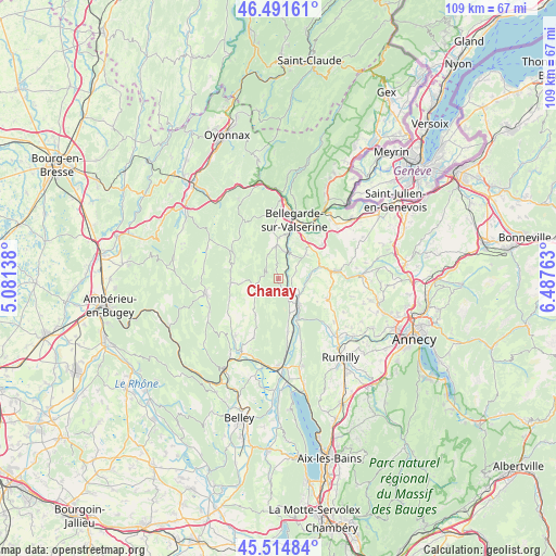
Chanay GPS coordinates[2]
46° 0' 19.368" North, 5° 47' 4.236" East
| Map corner | latitude | longitude |
|---|---|---|
| Upper-left | 46.49161°, | 5.08138° |
| Center: | 46.00538°, | 5.78451° |
| Lower-right: | 45.51484°, | 6.48763° |
| Map W x H: | 108.6×108.6 km | = 67.5×67.5mi |
| max Lat: | 51.07786° ⇑66.1% North |
| Chanay: | 46.00538° |
| min Lat: | ⇓33.9% South 41.3874° |
| min Long | Chanay | max Long |
| -5.08615° | 5.78451° | 9.52242° |
| W 85%⇐ | ⇒15% E |
Elevation
Elevation of Chanay is 409 m = 1342 ft, and this is 215.3 m = 706 ft above average elevation for this country.
| Max E: |
2333 m = 7654 ft | 10.9% |
| Chanay | 409 m 1342 ft | |
| Avg. | 193.7 m = 635 ft | |
Min E: |
-1 m = -3 ft | 89.1% |
See also: France elevation on elevation.city.
Geographical zone
Chanay is located in North temperate zone (between Tropic of Cancer and the Arctic Circle). Distance of this North polar circle is 2285.9 km =1420.4 mi to North.| Distance of | km | miles | from Chanay |
|---|---|---|---|
| North Pole | 4891.7 | 3039.6 | to North |
| Arctic Circle | 2285.9 | 1420.4 | to North |
| Tropic Cancer | 2509.4 | 1559.3 | to South |
| Equator | 5115.3 | 3178.5 | to South |


Nearby cities:
15 places around Chanay: (largest is in red/bold)
• Anglefort
10.6 km =6.6 mi,  169°
169°
• Bellegarde-sur-Valserine
11.8 km =7.3 mi,  15°
15°
• Chilly
13.2 km =8.2 mi,  96°
96°
• Corbonod
5.1 km =3.2 mi,  145°
145°
• Desingy
8.1 km =5 mi, 97°
• Frangy
11.5 km =7.1 mi,  81°
81°
• Génissiat
5.4 km =3.4 mi,  14°
14°
• Lancrans
14.1 km =8.8 mi, 15°
• Léaz
12.8 km =8 mi,  36°
36°
• Menthonnex-sous-Clermont
12.5 km =7.8 mi,  111°
111°
• Serrières-en-Chautagne
14.5 km =9 mi,  161°
161°
• Seyssel
6.3 km =3.9 mi,  144°
144°
• Seyssel
6.5 km =4 mi, 141°
• Versonnex
13.8 km =8.6 mi,  127°
127°
• Éloise
10.2 km =6.3 mi, 35°
Sources, notices
• [Note1] Compared only with cities in France existing in our database
• [Src1] Map data: © OpenStreetMap contributors (CC-BY-SA)
• [Src2] Other city data from geonames.org with taken over terms of usage.
• [Src3] Geographical zone / Annual Mean Temperature by Robert A. Rohde @ Wikipedia
