Haussy geodata
Haussy (Hauts-de-France) is a populated place; located in France in Europe/Paris (GMT+2) time zone. With population of 1,704 people, there are 5512 cities with bigger population in this country. Compared to other cities in France, 94.9% of cities are located further ↓South; 64% of cities are located further ←West and 79% of cities have higher elevation than Haussy. Note1
Administrative division(s):
- Level 1: Hauts-de-France
- Level 2: Nord
- Level 3: Arrondissement de Cambrai
- Level 4: Haussy


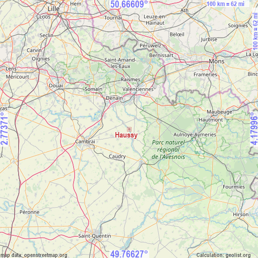
Haussy GPS coordinates[2]
50° 13' 5.88" North, 3° 28' 36.588" East
| Map corner | latitude | longitude |
|---|---|---|
| Upper-left | 50.66609°, | 2.77371° |
| Center: | 50.2183°, | 3.47683° |
| Lower-right: | 49.76627°, | 4.17996° |
| Map W x H: | 100.1×100 km | = 62.2×62.1mi |
| max Lat: | 51.07786° ⇑5.1% North |
| Haussy: | 50.2183° |
| min Lat: | ⇓94.9% South 41.3874° |
| min Long | Haussy | max Long |
| -5.08615° | 3.47683° | 9.52242° |
| W 64%⇐ | ⇒36% E |
Elevation
Elevation of Haussy is 57 m = 187 ft, and this is 136.7 m = 448 ft below average elevation for this country.
| Max E: |
2333 m = 7654 ft | 79% |
| Avg. | 193.7 m = 635 ft | |
| Haussy | 57 m = 187 ft | |
Min E: |
-1 m = -3 ft | 21% |
See also: France elevation on elevation.city.
Geographical zone
Haussy is located in North temperate zone (between Tropic of Cancer and the Arctic Circle). Distance of this North polar circle is 1817.4 km =1129.3 mi to North.| Distance of | km | miles | from Haussy |
|---|---|---|---|
| North Pole | 4423.3 | 2748.5 | to North |
| Arctic Circle | 1817.4 | 1129.3 | to North |
| Tropic Cancer | 2977.8 | 1850.3 | to South |
| Equator | 5583.8 | 3469.6 | to South |


Nearby cities:
15 places around Haussy: (largest is in red/bold)
• Avesnes-les-Aubert
7 km =4.3 mi,  252°
252°
• Bermerain
5.5 km =3.4 mi,  45°
45°
• Briastre
6.4 km =4 mi,  174°
174°
• Haspres
6.2 km =3.9 mi,  316°
316°
• Quiévy
6.6 km =4.1 mi,  211°
211°
• Saint-Aubert
4.4 km =2.7 mi, 254°
• Saint-Hilaire-lez-Cambrai
5.9 km =3.7 mi,  230°
230°
• Saint-Python
3.2 km =2 mi,  175°
175°
• Saint-Vaast-en-Cambrésis
4.7 km =2.9 mi,  244°
244°
• Saulzoir
3.4 km =2.1 mi, 316°
• Solesmes
4 km =2.5 mi,  158°
158°
• Vendegies-sur-Écaillon
5.5 km =3.4 mi,  27°
27°
• Verchain-Maugré
5.5 km =3.4 mi,  0°
0°
• Vertain
3.5 km =2.2 mi,  101°
101°
• Villers-en-Cauchies
5.3 km =3.3 mi,  279°
279°
Sources, notices
• [Note1] Compared only with cities in France existing in our database
• [Src1] Map data: © OpenStreetMap contributors (CC-BY-SA)
• [Src2] Other city data from geonames.org with taken over terms of usage.
• [Src3] Geographical zone / Annual Mean Temperature by Robert A. Rohde @ Wikipedia
