Avesnes-les-Aubert geodata
Avesnes-les-Aubert (Hauts-de-France) is a populated place; located in France in Europe/Paris (GMT+2) time zone. With population of 3,665 people, there are 2677 cities with bigger population in this country. Compared to other cities in France, 94.8% of cities are located further ↓South; 63% of cities are located further ←West and 78.6% of cities have higher elevation than Avesnes-les-Aubert. Note1
Administrative division(s):
- Level 1: Hauts-de-France
- Level 2: Nord
- Level 3: Arrondissement de Cambrai
- Level 4: Avesnes-les-Aubert


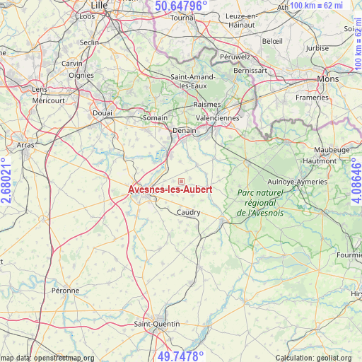
Avesnes-les-Aubert GPS coordinates[2]
50° 12' 0" North, 3° 22' 59.988" East
| Map corner | latitude | longitude |
|---|---|---|
| Upper-left | 50.64796°, | 2.68021° |
| Center: | 50.2°, | 3.38333° |
| Lower-right: | 49.7478°, | 4.08646° |
| Map W x H: | 100.1×100.1 km | = 62.2×62.2mi |
| max Lat: | 51.07786° ⇑5.2% North |
| Avesnes-les-Aubert: | 50.2° |
| min Lat: | ⇓94.8% South 41.3874° |
| min Long | Avesnes-les-Aub | max Long |
| -5.08615° | 3.38333° | 9.52242° |
| W 63%⇐ | ⇒37% E |
Elevation
Elevation of Avesnes-les-Aubert is 58 m = 190 ft, and this is 135.7 m = 445 ft below average elevation for this country.
| Max E: |
2333 m = 7654 ft | 78.6% |
| Avg. | 193.7 m = 635 ft | |
| Avesnes-les-Aubert | 58 m = 190 ft | |
Min E: |
-1 m = -3 ft | 21.4% |
See also: France elevation on elevation.city.
Geographical zone
Avesnes-les-Aubert is located in North temperate zone (between Tropic of Cancer and the Arctic Circle). Distance of this North polar circle is 1819.5 km =1130.6 mi to North.| Distance of | km | miles | from Avesnes-les-Aubert |
|---|---|---|---|
| North Pole | 4425.3 | 2749.8 | to North |
| Arctic Circle | 1819.5 | 1130.6 | to North |
| Tropic Cancer | 2975.8 | 1849.1 | to South |
| Equator | 5581.7 | 3468.3 | to South |


Nearby cities:
15 places around Avesnes-les-Aubert: (largest is in red/bold)
• Avesnes-le-Sec
5.7 km =3.5 mi,  355°
355°
• Bévillers
4.8 km =3 mi,  174°
174°
• Carnières
4.4 km =2.7 mi,  215°
215°
• Cauroir
6.5 km =4 mi,  242°
242°
• Haspres
6.9 km =4.3 mi,  20°
20°
• Haussy
7 km =4.3 mi,  72°
72°
• Iwuy
5.8 km =3.6 mi,  309°
309°
• Naves
4.8 km =3 mi,  273°
273°
• Quiévy
4.8 km =3 mi,  137°
137°
• Rieux-en-Cambrésis
2.2 km =1.4 mi, 271°
• Saint-Aubert
2.6 km =1.6 mi, 69°
• Saint-Hilaire-lez-Cambrai
2.8 km =1.7 mi,  129°
129°
• Saint-Vaast-en-Cambrésis
2.4 km =1.5 mi,  90°
90°
• Saulzoir
6.3 km =3.9 mi,  43°
43°
• Villers-en-Cauchies
3.2 km =2 mi,  26°
26°
Sources, notices
• [Note1] Compared only with cities in France existing in our database
• [Src1] Map data: © OpenStreetMap contributors (CC-BY-SA)
• [Src2] Other city data from geonames.org with taken over terms of usage.
• [Src3] Geographical zone / Annual Mean Temperature by Robert A. Rohde @ Wikipedia
