Saint-Vaast-en-Cambrésis geodata
Saint-Vaast-en-Cambrésis (Hauts-de-France) is a populated place; located in France in Europe/Paris (GMT+2) time zone. With population of 874 people, there are 9865 cities with bigger population in this country. Compared to other cities in France, 94.8% of cities are located further ↓South; 63.4% of cities are located further ←West and 74.1% of cities have higher elevation than Saint-Vaast-en-Cambrésis. Note1
Administrative division(s):
- Level 1: Hauts-de-France
- Level 2: Nord
- Level 3: Arrondissement de Cambrai
- Level 4: Saint-Vaast-en-Cambrésis
Current local time in Saint-Vaast-en-Cambrésis:
01:59 AM, SaturdayDifference from your time zone: hours


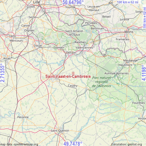
Saint-Vaast-en-Cambrésis GPS coordinates[2]
50° 12' 0" North, 3° 25' 0.012" East
| Map corner | latitude | longitude |
|---|---|---|
| Upper-left | 50.64796°, | 2.71355° |
| Center: | 50.2°, | 3.41667° |
| Lower-right: | 49.7478°, | 4.1198° |
| Map W x H: | 100.1×100.1 km | = 62.2×62.2mi |
| max Lat: | 51.07786° ⇑5.2% North |
| Saint-Vaast-en-Cambrésis: | 50.2° |
| min Lat: | ⇓94.8% South 41.3874° |
| min Long | Saint-Vaast-en- | max Long |
| -5.08615° | 3.41667° | 9.52242° |
| W 63.4%⇐ | ⇒36.6% E |
Elevation
Elevation of Saint-Vaast-en-Cambrésis is 69 m = 226 ft, and this is 124.7 m = 409 ft below average elevation for this country.
| Max E: |
2333 m = 7654 ft | 74.1% |
| Avg. | 193.7 m = 635 ft | |
| Saint-Vaast-en-Cambrésis | 69 m = 226 ft | |
Min E: |
-1 m = -3 ft | 25.9% |
See also: France elevation on elevation.city.
Geographical zone
Saint-Vaast-en-Cambrésis is located in North temperate zone (between Tropic of Cancer and the Arctic Circle). Distance of this North polar circle is 1819.5 km =1130.6 mi to North.| Distance of | km | miles | from Saint-Vaast-en-Cambrésis |
|---|---|---|---|
| North Pole | 4425.3 | 2749.8 | to North |
| Arctic Circle | 1819.5 | 1130.6 | to North |
| Tropic Cancer | 2975.8 | 1849.1 | to South |
| Equator | 5581.7 | 3468.3 | to South |


Nearby cities:
15 places around Saint-Vaast-en-Cambrésis: (largest is in red/bold)
• Avesnes-le-Sec
6.3 km =3.9 mi,  333°
333°
• Avesnes-les-Aubert
2.4 km =1.5 mi,  270°
270°
• Bévillers
5.1 km =3.2 mi,  201°
201°
• Carnières
6.1 km =3.8 mi,  234°
234°
• Haspres
6.5 km =4 mi,  0°
0°
• Haussy
4.7 km =2.9 mi,  64°
64°
• Quiévy
3.6 km =2.2 mi,  166°
166°
• Rieux-en-Cambrésis
4.6 km =2.9 mi, 270°
• Saint-Aubert
0.9 km =0.6 mi, 2°
• Saint-Hilaire-lez-Cambrai
1.8 km =1.1 mi,  187°
187°
• Saint-Python
4.7 km =2.9 mi,  103°
103°
• Saulzoir
4.9 km =3 mi,  23°
23°
• Solesmes
6 km =3.7 mi,  106°
106°
• Viesly
6.1 km =3.8 mi,  147°
147°
• Villers-en-Cauchies
3 km =1.9 mi,  342°
342°
Sources, notices
• [Note1] Compared only with cities in France existing in our database
• [Src1] Map data: © OpenStreetMap contributors (CC-BY-SA)
• [Src2] Other city data from geonames.org with taken over terms of usage.
• [Src3] Geographical zone / Annual Mean Temperature by Robert A. Rohde @ Wikipedia
