Hélette geodata
Hélette (Nouvelle-Aquitaine) is a populated place; located in France in Europe/Paris (GMT+1) time zone. With population of 663 people, there are 12328 cities with bigger population in this country. Compared to other cities in France, 95.5% of cities are located further ↑North; 90.4% of cities are located further →East and 76.5% of cities have lower elevation than Hélette. Note1
Administrative division(s):
- Level 1: Nouvelle-Aquitaine
- Level 2: Département des Pyrénées-Atlantiques
- Level 3: Arrondissement de Bayonne
- Level 4: Hélette


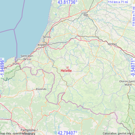
Hélette GPS coordinates[2]
43° 18' 28.332" North, 1° 14' 37.788" West
| Map corner | latitude | longitude |
|---|---|---|
| Upper-left | 43.81736°, | -1.94696° |
| Center: | 43.30787°, | -1.24383° |
| Lower-right: | 42.79407°, | -0.54071° |
| Map W x H: | 113.8×113.8 km | = 70.7×70.7mi |
| max Lat: | 51.07786° ⇑95.5% North |
| Hélette: | 43.30787° |
| min Lat: | ⇓4.5% South 41.3874° |
| min Long | Hélette | max Long |
| -5.08615° | -1.24383° | 9.52242° |
| W 9.6%⇐ | ⇒90.4% E |
Elevation
Elevation of Hélette is 260 m = 853 ft, and this is 66.3 m = 218 ft above average elevation for this country.
| Max E: |
2333 m = 7654 ft | 23.5% |
| Hélette | 260 m 853 ft | |
| Avg. | 193.7 m = 635 ft | |
Min E: |
-1 m = -3 ft | 76.5% |
See also: France elevation on elevation.city.
Geographical zone
Hélette is located in North temperate zone (between Tropic of Cancer and the Arctic Circle). Distance of this Northern Tropic circle is 2209.5 km =1372.9 mi to South.| Distance of | km | miles | from Hélette |
|---|---|---|---|
| North Pole | 5191.7 | 3226 | to North |
| Arctic Circle | 2585.8 | 1606.7 | to North |
| Tropic Cancer | 2209.5 | 1372.9 | to South |
| Equator | 4815.4 | 2992.1 | to South |


Nearby cities:
15 places around Hélette: (largest is in red/bold)
• Ayherre
9.3 km =5.8 mi,  354°
354°
• Beyrie-sur-Joyeuse
14.4 km =8.9 mi,  86°
86°
• Bidarray
9.6 km =6 mi,  240°
240°
• Cambo-les-Bains
13.9 km =8.6 mi,  293°
293°
• Hasparren
9.8 km =6.1 mi,  329°
329°
• Irissarry
5.7 km =3.5 mi,  170°
170°
• Ispoure
15.4 km =9.6 mi,  177°
177°
• Itxassou
13.3 km =8.3 mi,  280°
280°
• Louhossoa
8.7 km =5.4 mi, 276°
• Macaye
6.7 km =4.2 mi, 292°
• Mendionde
5.7 km =3.5 mi,  307°
307°
• Orègue
13 km =8.1 mi,  42°
42°
• Ossès
8.1 km =5 mi,  204°
204°
• Saint-Jean-Pied-de-Port
16 km =9.9 mi, 178°
• Uhart-Cize
16.2 km =10.1 mi, 179°
Sources, notices
• [Note1] Compared only with cities in France existing in our database
• [Src1] Map data: © OpenStreetMap contributors (CC-BY-SA)
• [Src2] Other city data from geonames.org with taken over terms of usage.
• [Src3] Geographical zone / Annual Mean Temperature by Robert A. Rohde @ Wikipedia
