Feldkirch geodata
Feldkirch (Grand Est) is a populated place; located in France in Europe/Paris (GMT+2) time zone. With population of 949 people, there are 9213 cities with bigger population in this country. Compared to other cities in France, 56.8% of cities are located further ↓South; 96.3% of cities are located further ←West and 71.7% of cities have lower elevation than Feldkirch. Note1
Administrative division(s):
- Level 1: Grand Est
- Level 2: Haut-Rhin
- Level 3: Arrondissement de Mulhouse
- Level 4: Feldkirch


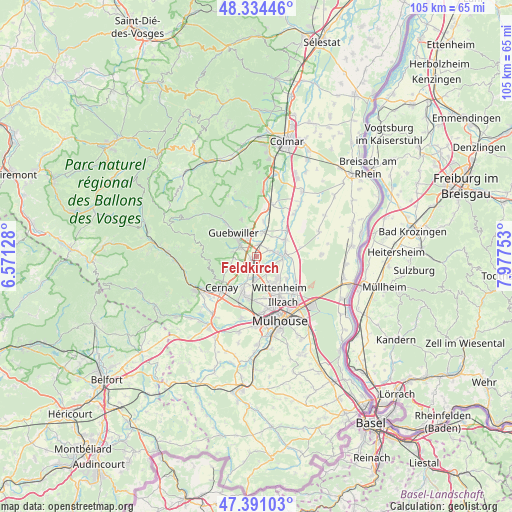
Feldkirch GPS coordinates[2]
47° 51' 53.604" North, 7° 16' 27.876" East
| Map corner | latitude | longitude |
|---|---|---|
| Upper-left | 48.33446°, | 6.57128° |
| Center: | 47.86489°, | 7.27441° |
| Lower-right: | 47.39103°, | 7.97753° |
| Map W x H: | 104.9×104.9 km | = 65.2×65.2mi |
| max Lat: | 51.07786° ⇑43.2% North |
| Feldkirch: | 47.86489° |
| min Lat: | ⇓56.8% South 41.3874° |
| min Long | Feldkirch | max Long |
| -5.08615° | 7.27441° | 9.52242° |
| W 96.3%⇐ | ⇒3.7% E |
Elevation
Elevation of Feldkirch is 228 m = 748 ft, and this is 34.3 m = 113 ft above average elevation for this country.
| Max E: |
2333 m = 7654 ft | 28.3% |
| Feldkirch | 228 m 748 ft | |
| Avg. | 193.7 m = 635 ft | |
Min E: |
-1 m = -3 ft | 71.7% |
See also: France elevation on elevation.city.
Geographical zone
Feldkirch is located in North temperate zone (between Tropic of Cancer and the Arctic Circle). Distance of this North polar circle is 2079.1 km =1291.9 mi to North.| Distance of | km | miles | from Feldkirch |
|---|---|---|---|
| North Pole | 4685 | 2911.1 | to North |
| Arctic Circle | 2079.1 | 1291.9 | to North |
| Tropic Cancer | 2716.2 | 1687.8 | to South |
| Equator | 5322.1 | 3307 | to South |


Nearby cities:
15 places around Feldkirch: (largest is in red/bold)
• Bergholtz
6.1 km =3.8 mi,  340°
340°
• Berrwiller
4.4 km =2.7 mi,  247°
247°
• Bollwiller
1.2 km =0.7 mi,  232°
232°
• Ensisheim
5.7 km =3.5 mi,  88°
88°
• Hartmannswiller
4.4 km =2.7 mi,  265°
265°
• Issenheim
4.6 km =2.9 mi, 339°
• Jungholtz
6.2 km =3.9 mi,  290°
290°
• Merxheim
5.4 km =3.4 mi,  16°
16°
• Pulversheim
3.6 km =2.2 mi,  146°
146°
• Raedersheim
2.7 km =1.7 mi,  12°
12°
• Soultz-Haut-Rhin
4.3 km =2.7 mi,  307°
307°
• Staffelfelden
4.6 km =2.9 mi,  201°
201°
• Ungersheim
2.9 km =1.8 mi,  58°
58°
• Wittelsheim
6.6 km =4.1 mi, 201°
• Wuenheim
5.2 km =3.2 mi,  281°
281°
Sources, notices
• [Note1] Compared only with cities in France existing in our database
• [Src1] Map data: © OpenStreetMap contributors (CC-BY-SA)
• [Src2] Other city data from geonames.org with taken over terms of usage.
• [Src3] Geographical zone / Annual Mean Temperature by Robert A. Rohde @ Wikipedia
