Carresse-Cassaber geodata
Carresse-Cassaber (Nouvelle-Aquitaine) is a populated place; located in France in Europe/Paris (GMT+2) time zone. With population of 502 people, there are 15200 cities with bigger population in this country. Compared to other cities in France, 93.3% of cities are located further ↑North; 88.2% of cities are located further →East and 88.3% of cities have higher elevation than Carresse-Cassaber. Note1
Administrative division(s):
- Level 1: Nouvelle-Aquitaine
- Level 2: Département des Pyrénées-Atlantiques
- Level 3: Oloron-Sainte-Marie
- Level 4: Carresse-Cassaber


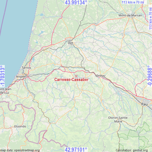
Carresse-Cassaber GPS coordinates[2]
43° 28' 59.988" North, 1° 0' 0" West
| Map corner | latitude | longitude |
|---|---|---|
| Upper-left | 43.99134°, | -1.70313° |
| Center: | 43.48333°, | -1° |
| Lower-right: | 42.97101°, | -0.29688° |
| Map W x H: | 113.5×113.4 km | = 70.5×70.5mi |
| max Lat: | 51.07786° ⇑93.3% North |
| Carresse-Cassaber: | 43.48333° |
| min Lat: | ⇓6.7% South 41.3874° |
| min Long | Carresse-Cassab | max Long |
| -5.08615° | -1° | 9.52242° |
| W 11.8%⇐ | ⇒88.2% E |
Elevation
Elevation of Carresse-Cassaber is 34 m = 112 ft, and this is 159.7 m = 524 ft below average elevation for this country.
| Max E: |
2333 m = 7654 ft | 88.3% |
| Avg. | 193.7 m = 635 ft | |
| Carresse-Cassaber | 34 m = 112 ft | |
Min E: |
-1 m = -3 ft | 11.7% |
See also: France elevation on elevation.city.
Geographical zone
Carresse-Cassaber is located in North temperate zone (between Tropic of Cancer and the Arctic Circle). Distance of this Northern Tropic circle is 2229 km =1385 mi to South.| Distance of | km | miles | from Carresse-Cassaber |
|---|---|---|---|
| North Pole | 5172.2 | 3213.9 | to North |
| Arctic Circle | 2566.3 | 1594.6 | to North |
| Tropic Cancer | 2229 | 1385 | to South |
| Equator | 4834.9 | 3004.3 | to South |


Nearby cities:
15 places around Carresse-Cassaber: (largest is in red/bold)
• Baigts-de-Béarn
13.4 km =8.3 mi,  75°
75°
• Bellocq
7.7 km =4.8 mi,  61°
61°
• Bidache
11.4 km =7.1 mi,  269°
269°
• Bérenx
12.2 km =7.6 mi, 81°
• Cagnotte
13.6 km =8.5 mi,  336°
336°
• Came
9.7 km =6 mi,  262°
262°
• Cauneille
8.5 km =5.3 mi,  325°
325°
• Habas
11.4 km =7.1 mi,  29°
29°
• Labatut
7.5 km =4.7 mi,  10°
10°
• Misson
12.5 km =7.8 mi,  15°
15°
• Peyrehorade
11.8 km =7.3 mi,  307°
307°
• Pouillon
13.5 km =8.4 mi,  0°
0°
• Puyoô
8.4 km =5.2 mi, 56°
• Salies-de-Béarn
6.2 km =3.9 mi,  99°
99°
• Sauveterre-de-Béarn
10.7 km =6.6 mi,  149°
149°
Sources, notices
• [Note1] Compared only with cities in France existing in our database
• [Src1] Map data: © OpenStreetMap contributors (CC-BY-SA)
• [Src2] Other city data from geonames.org with taken over terms of usage.
• [Src3] Geographical zone / Annual Mean Temperature by Robert A. Rohde @ Wikipedia
