Gujan-Mestras geodata
Gujan-Mestras (Nouvelle-Aquitaine) is a populated place; located in France in Europe/Paris (GMT+2) time zone. With population of 19,184 people, there are 479 cities with bigger population in this country. Compared to other cities in France, 82.6% of cities are located further ↑North; 88.9% of cities are located further →East and 98.6% of cities have higher elevation than Gujan-Mestras. Note1
Administrative division(s):
- Level 1: Nouvelle-Aquitaine
- Level 2: Gironde
- Level 3: Arrondissement d'Arcachon
- Level 4: Gujan-Mestras


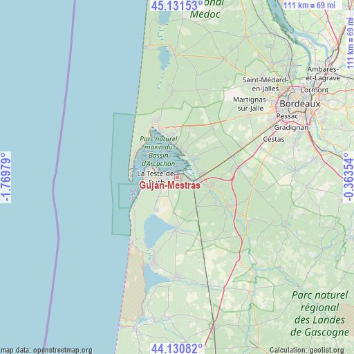
Gujan-Mestras GPS coordinates[2]
44° 37' 59.988" North, 1° 4' 0.012" West
| Map corner | latitude | longitude |
|---|---|---|
| Upper-left | 45.13153°, | -1.76979° |
| Center: | 44.63333°, | -1.06667° |
| Lower-right: | 44.13082°, | -0.36354° |
| Map W x H: | 111.3×111.3 km | = 69.2×69.2mi |
| max Lat: | 51.07786° ⇑82.6% North |
| Gujan-Mestras: | 44.63333° |
| min Lat: | ⇓17.4% South 41.3874° |
| min Long | Gujan-Mestras | max Long |
| -5.08615° | -1.06667° | 9.52242° |
| W 11.1%⇐ | ⇒88.9% E |
Elevation
Elevation of Gujan-Mestras is 7 m = 23 ft, and this is 186.7 m = 613 ft below average elevation for this country.
| Max E: |
2333 m = 7654 ft | 98.6% |
| Avg. | 193.7 m = 635 ft | |
| Gujan-Mestras | 7 m = 23 ft | |
Min E: |
-1 m = -3 ft | 1.4% |
See also: France elevation on elevation.city.
Geographical zone
Gujan-Mestras is located in North temperate zone (between Tropic of Cancer and the Arctic Circle). Distance of this Northern Tropic circle is 2356.8 km =1464.4 mi to South.| Distance of | km | miles | from Gujan-Mestras |
|---|---|---|---|
| North Pole | 5044.3 | 3134.4 | to North |
| Arctic Circle | 2438.4 | 1515.2 | to North |
| Tropic Cancer | 2356.8 | 1464.4 | to South |
| Equator | 4962.8 | 3083.7 | to South |


Nearby cities:
15 places around Gujan-Mestras: (largest is in red/bold)
• Andernos-les-Bains
12.8 km =8 mi,  346°
346°
• Arcachon
8.6 km =5.3 mi,  289°
289°
• Arès
15.7 km =9.8 mi,  340°
340°
• Audenge
7.3 km =4.5 mi,  35°
35°
• Biganos
7.5 km =4.7 mi,  79°
79°
• La Teste-de-Buch
5.9 km =3.7 mi,  265°
265°
• Lanton
8.3 km =5.2 mi,  17°
17°
• Le Barp
23.7 km =14.7 mi,  96°
96°
• Le Porge
26.7 km =16.6 mi,  356°
356°
• Le Teich
3.6 km =2.2 mi,  92°
92°
• Lugos
22.2 km =13.8 mi,  139°
139°
• Marcheprime
17.9 km =11.1 mi,  68°
68°
• Mios
11 km =6.8 mi,  106°
106°
• Salles
18.8 km =11.7 mi,  119°
119°
• Sanguinet
16.7 km =10.4 mi,  182°
182°
Sources, notices
• [Note1] Compared only with cities in France existing in our database
• [Src1] Map data: © OpenStreetMap contributors (CC-BY-SA)
• [Src2] Other city data from geonames.org with taken over terms of usage.
• [Src3] Geographical zone / Annual Mean Temperature by Robert A. Rohde @ Wikipedia
