Le Porge geodata
Le Porge (Nouvelle-Aquitaine) is a populated place; located in France in Europe/Paris (GMT+2) time zone. With population of 1,641 people, there are 5693 cities with bigger population in this country. Compared to other cities in France, 80.7% of cities are located further ↑North; 89% of cities are located further →East and 92.4% of cities have higher elevation than Le Porge. Note1
Administrative division(s):
- Level 1: Nouvelle-Aquitaine
- Level 2: Gironde
- Level 3: Arrondissement de Lesparre-Médoc
- Level 4: Le Porge


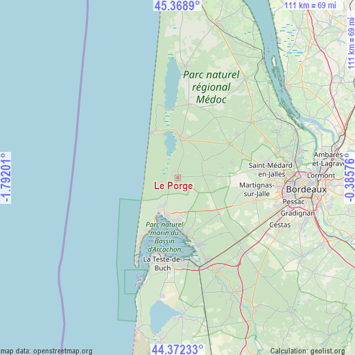
Le Porge GPS coordinates[2]
44° 52' 21.972" North, 1° 5' 20.004" West
| Map corner | latitude | longitude |
|---|---|---|
| Upper-left | 45.3689°, | -1.79201° |
| Center: | 44.87277°, | -1.08889° |
| Lower-right: | 44.37233°, | -0.38576° |
| Map W x H: | 110.8×110.8 km | = 68.8×68.8mi |
| max Lat: | 51.07786° ⇑80.7% North |
| Le Porge: | 44.87277° |
| min Lat: | ⇓19.3% South 41.3874° |
| min Long | Le Porge | max Long |
| -5.08615° | -1.08889° | 9.52242° |
| W 11%⇐ | ⇒89% E |
Elevation
Elevation of Le Porge is 24 m = 79 ft, and this is 169.7 m = 557 ft below average elevation for this country.
| Max E: |
2333 m = 7654 ft | 92.4% |
| Avg. | 193.7 m = 635 ft | |
| Le Porge | 24 m = 79 ft | |
Min E: |
-1 m = -3 ft | 7.6% |
See also: France elevation on elevation.city.
Geographical zone
Le Porge is located in North temperate zone (between Tropic of Cancer and the Arctic Circle). Distance of this Northern Tropic circle is 2383.5 km =1481 mi to South.| Distance of | km | miles | from Le Porge |
|---|---|---|---|
| North Pole | 5017.7 | 3117.9 | to North |
| Arctic Circle | 2411.8 | 1498.6 | to North |
| Tropic Cancer | 2383.5 | 1481 | to South |
| Equator | 4989.4 | 3100.3 | to South |


Nearby cities:
15 places around Le Porge: (largest is in red/bold)
• Andernos-les-Bains
14.2 km =8.8 mi,  184°
184°
• Arcachon
24.6 km =15.3 mi,  194°
194°
• Arès
12.3 km =7.6 mi,  196°
196°
• Audenge
21.5 km =13.4 mi,  163°
163°
• Biganos
26.9 km =16.7 mi, 160°
• Carcans
23.2 km =14.4 mi,  8°
8°
• Gujan-Mestras
26.7 km =16.6 mi, 176°
• Lacanau
11.7 km =7.3 mi,  4°
4°
• Lanton
19.1 km =11.9 mi,  167°
167°
• Le Temple
7.9 km =4.9 mi,  84°
84°
• Marcheprime
27.3 km =17 mi,  137°
137°
• Martignas-sur-Jalle
24.5 km =15.2 mi,  97°
97°
• Saint-Jean-d’Illac
24.9 km =15.5 mi,  106°
106°
• Sainte-Hélène
19.3 km =12 mi,  57°
57°
• Salaunes
21.5 km =13.4 mi,  70°
70°
Sources, notices
• [Note1] Compared only with cities in France existing in our database
• [Src1] Map data: © OpenStreetMap contributors (CC-BY-SA)
• [Src2] Other city data from geonames.org with taken over terms of usage.
• [Src3] Geographical zone / Annual Mean Temperature by Robert A. Rohde @ Wikipedia
