Guilly geodata
Guilly (Centre) is a populated place; located in France in Europe/Paris (GMT+2) time zone. With population of 644 people, there are 12610 cities with bigger population in this country. Compared to other cities in France, 55.8% of cities are located further ↓South; 53.1% of cities are located further →East and 56.5% of cities have higher elevation than Guilly. Note1
Administrative division(s):
- Level 1: Centre
- Level 2: Loiret
- Level 3: Arrondissement d’Orléans
- Level 4: Guilly


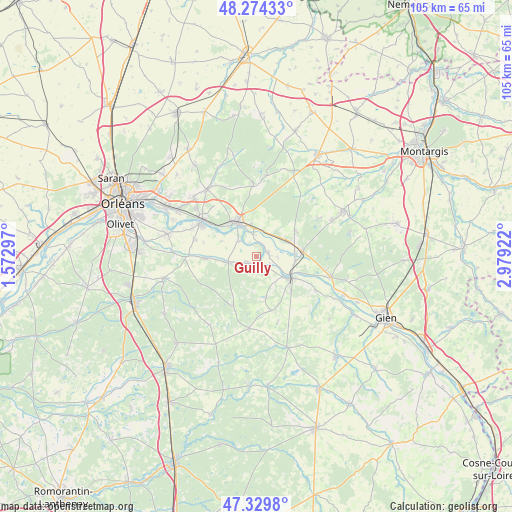
Guilly GPS coordinates[2]
47° 48' 15.156" North, 2° 16' 33.924" East
| Map corner | latitude | longitude |
|---|---|---|
| Upper-left | 48.27433°, | 1.57297° |
| Center: | 47.80421°, | 2.27609° |
| Lower-right: | 47.3298°, | 2.97922° |
| Map W x H: | 105×105 km | = 65.2×65.2mi |
| max Lat: | 51.07786° ⇑44.2% North |
| Guilly: | 47.80421° |
| min Lat: | ⇓55.8% South 41.3874° |
| min Long | Guilly | max Long |
| -5.08615° | 2.27609° | 9.52242° |
| W 46.9%⇐ | ⇒53.1% E |
Elevation
Elevation of Guilly is 112 m = 367 ft, and this is 81.7 m = 268 ft below average elevation for this country.
| Max E: |
2333 m = 7654 ft | 56.5% |
| Avg. | 193.7 m = 635 ft | |
| Guilly | 112 m = 367 ft | |
Min E: |
-1 m = -3 ft | 43.5% |
See also: France elevation on elevation.city.
Geographical zone
Guilly is located in North temperate zone (between Tropic of Cancer and the Arctic Circle). Distance of this North polar circle is 2085.8 km =1296.1 mi to North.| Distance of | km | miles | from Guilly |
|---|---|---|---|
| North Pole | 4691.7 | 2915.3 | to North |
| Arctic Circle | 2085.8 | 1296.1 | to North |
| Tropic Cancer | 2709.4 | 1683.5 | to South |
| Equator | 5315.3 | 3302.8 | to South |


Nearby cities:
15 places around Guilly: (largest is in red/bold)
• Bonnée
8.1 km =5 mi,  96°
96°
• Bouzy-la-Forêt
9.2 km =5.7 mi,  55°
55°
• Bray-en-Val
7.3 km =4.5 mi,  68°
68°
• Châteauneuf-sur-Loire
8.1 km =5 mi,  328°
328°
• Férolles
12.8 km =8 mi,  285°
285°
• Germigny-des-Prés
4.5 km =2.8 mi,  353°
353°
• Neuvy-en-Sullias
2.6 km =1.6 mi,  246°
246°
• Saint-Benoît-sur-Loire
2.7 km =1.7 mi,  86°
86°
• Saint-Père-sur-Loire
8 km =5 mi,  121°
121°
• Sigloy
5 km =3.1 mi,  311°
311°
• Sully-sur-Loire
8.5 km =5.3 mi, 122°
• Tigy
6 km =3.7 mi,  258°
258°
• Vannes-sur-Cosson
11.2 km =7 mi,  205°
205°
• Vienne-en-Val
10.6 km =6.6 mi,  267°
267°
• Viglain
8.7 km =5.4 mi,  166°
166°
Sources, notices
• [Note1] Compared only with cities in France existing in our database
• [Src1] Map data: © OpenStreetMap contributors (CC-BY-SA)
• [Src2] Other city data from geonames.org with taken over terms of usage.
• [Src3] Geographical zone / Annual Mean Temperature by Robert A. Rohde @ Wikipedia
