Bray-en-Val geodata
Bray-en-Val (Centre) is a populated place; located in France in Europe/Paris (GMT+2) time zone. With population of 1,102 people, there are 8120 cities with bigger population in this country. Compared to other cities in France, 56.3% of cities are located further ↓South; 51.6% of cities are located further →East and 51.7% of cities have higher elevation than Bray-en-Val. Note1
Administrative division(s):
- Level 1: Centre
- Level 2: Loiret
- Level 3: Arrondissement d’Orléans
- Level 4: Bray-Saint-Aignan


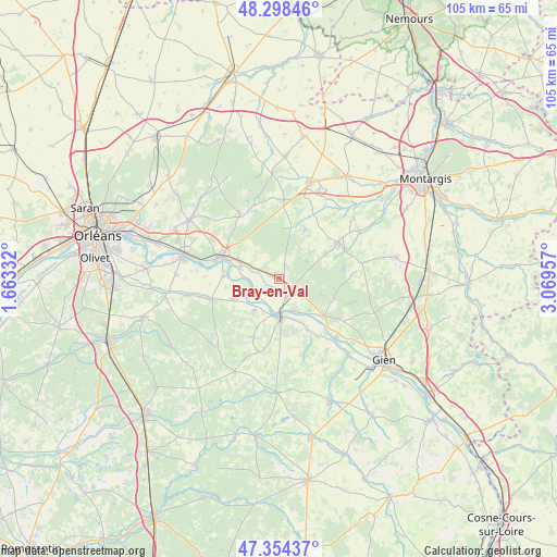
Bray-en-Val GPS coordinates[2]
47° 49' 42.816" North, 2° 21' 59.184" East
| Map corner | latitude | longitude |
|---|---|---|
| Upper-left | 48.29846°, | 1.66332° |
| Center: | 47.82856°, | 2.36644° |
| Lower-right: | 47.35437°, | 3.06957° |
| Map W x H: | 105×105 km | = 65.2×65.2mi |
| max Lat: | 51.07786° ⇑43.7% North |
| Bray-en-Val: | 47.82856° |
| min Lat: | ⇓56.3% South 41.3874° |
| min Long | Bray-en-Val | max Long |
| -5.08615° | 2.36644° | 9.52242° |
| W 48.4%⇐ | ⇒51.6% E |
Elevation
Elevation of Bray-en-Val is 126 m = 413 ft, and this is 67.7 m = 222 ft below average elevation for this country.
| Max E: |
2333 m = 7654 ft | 51.7% |
| Avg. | 193.7 m = 635 ft | |
| Bray-en-Val | 126 m = 413 ft | |
Min E: |
-1 m = -3 ft | 48.3% |
See also: France elevation on elevation.city.
Geographical zone
Bray-en-Val is located in North temperate zone (between Tropic of Cancer and the Arctic Circle). Distance of this North polar circle is 2083.1 km =1294.4 mi to North.| Distance of | km | miles | from Bray-en-Val |
|---|---|---|---|
| North Pole | 4689 | 2913.6 | to North |
| Arctic Circle | 2083.1 | 1294.4 | to North |
| Tropic Cancer | 2712.1 | 1685.2 | to South |
| Equator | 5318 | 3304.5 | to South |


Nearby cities:
15 places around Bray-en-Val: (largest is in red/bold)
• Bonnée
3.8 km =2.4 mi,  160°
160°
• Bouzy-la-Forêt
2.7 km =1.7 mi,  18°
18°
• Châteauneuf-sur-Loire
11.8 km =7.3 mi,  290°
290°
• Germigny-des-Prés
7.5 km =4.7 mi,  284°
284°
• Guilly
7.3 km =4.5 mi,  248°
248°
• Lorris
13 km =8.1 mi,  58°
58°
• Neuvy-en-Sullias
9.9 km =6.2 mi, 247°
• Ouzouer-sur-Loire
11 km =6.8 mi,  129°
129°
• Saint-Aignan-le-Jaillard
10.9 km =6.8 mi,  151°
151°
• Saint-Benoît-sur-Loire
4.8 km =3 mi,  237°
237°
• Saint-Père-sur-Loire
6.9 km =4.3 mi,  179°
179°
• Sigloy
10.5 km =6.5 mi,  273°
273°
• Sully-sur-Loire
7.2 km =4.5 mi, 176°
• Tigy
13.2 km =8.2 mi, 252°
• Viglain
12.1 km =7.5 mi,  203°
203°
Sources, notices
• [Note1] Compared only with cities in France existing in our database
• [Src1] Map data: © OpenStreetMap contributors (CC-BY-SA)
• [Src2] Other city data from geonames.org with taken over terms of usage.
• [Src3] Geographical zone / Annual Mean Temperature by Robert A. Rohde @ Wikipedia
