Guilberville geodata
Guilberville (Normandy) is a populated place; located in France in Europe/Paris (GMT+2) time zone. With population of 909 people, there are 9582 cities with bigger population in this country. Compared to other cities in France, 79.4% of cities are located further ↓South; 87.7% of cities are located further →East and 53.6% of cities have lower elevation than Guilberville. Note1
Administrative division(s):
- Level 1: Normandy
- Level 2: Manche
- Level 3: Arrondissement de Saint-Lô
- Level 4: Torigny-les-Villes


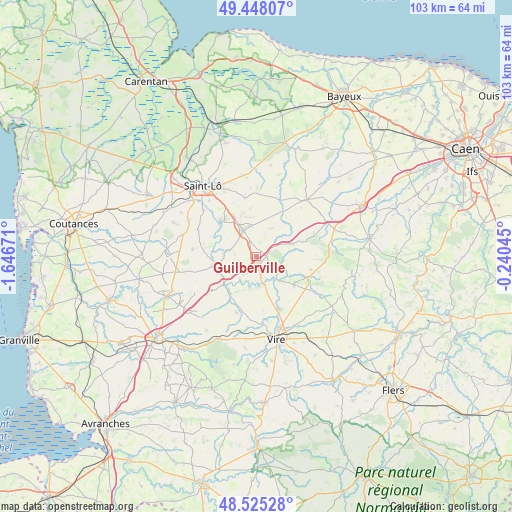
Guilberville GPS coordinates[2]
48° 59' 19.716" North, 0° 56' 36.888" West
| Map corner | latitude | longitude |
|---|---|---|
| Upper-left | 49.44807°, | -1.64671° |
| Center: | 48.98881°, | -0.94358° |
| Lower-right: | 48.52528°, | -0.24045° |
| Map W x H: | 102.6×102.6 km | = 63.8×63.8mi |
| max Lat: | 51.07786° ⇑20.6% North |
| Guilberville: | 48.98881° |
| min Lat: | ⇓79.4% South 41.3874° |
| min Long | Guilberville | max Long |
| -5.08615° | -0.94358° | 9.52242° |
| W 12.3%⇐ | ⇒87.7% E |
Elevation
Elevation of Guilberville is 145 m = 476 ft, and this is 48.7 m = 160 ft below average elevation for this country.
| Max E: |
2333 m = 7654 ft | 46.4% |
| Avg. | 193.7 m = 635 ft | |
| Guilberville | 145 m = 476 ft | |
Min E: |
-1 m = -3 ft | 53.6% |
See also: France elevation on elevation.city.
Geographical zone
Guilberville is located in North temperate zone (between Tropic of Cancer and the Arctic Circle). Distance of this North polar circle is 1954.1 km =1214.2 mi to North.| Distance of | km | miles | from Guilberville |
|---|---|---|---|
| North Pole | 4560 | 2833.5 | to North |
| Arctic Circle | 1954.1 | 1214.2 | to North |
| Tropic Cancer | 2841.1 | 1765.4 | to South |
| Equator | 5447 | 3384.6 | to South |


Nearby cities:
15 places around Guilberville: (largest is in red/bold)
• Campeaux
4.4 km =2.7 mi,  168°
168°
• Condé-sur-Vire
9.4 km =5.8 mi,  316°
316°
• Domjean
6.5 km =4 mi,  268°
268°
• Giéville
3.8 km =2.4 mi, 318°
• Landelles-et-Coupigny
12 km =7.5 mi,  199°
199°
• Le Bény-Bocage
9.6 km =6 mi,  127°
127°
• Le Tourneur
9.5 km =5.9 mi,  107°
107°
• Moyon
12.8 km =8 mi,  275°
275°
• Saint-Amand
6.3 km =3.9 mi,  345°
345°
• Saint-Jean-des-Baisants
11.9 km =7.4 mi, 349°
• Saint-Martin-des-Besaces
7.6 km =4.7 mi,  71°
71°
• Sainte-Marie-Laumont
8.8 km =5.5 mi,  152°
152°
• Sainte-Suzanne-sur-Vire
11.7 km =7.3 mi,  313°
313°
• Tessy-sur-Vire
8.7 km =5.4 mi,  258°
258°
• Torigni-sur-Vire
6.1 km =3.8 mi,  332°
332°
Sources, notices
• [Note1] Compared only with cities in France existing in our database
• [Src1] Map data: © OpenStreetMap contributors (CC-BY-SA)
• [Src2] Other city data from geonames.org with taken over terms of usage.
• [Src3] Geographical zone / Annual Mean Temperature by Robert A. Rohde @ Wikipedia
