Domjean geodata
Domjean (Normandy) is a populated place; located in France in Europe/Paris (GMT+2) time zone. With population of 837 people, there are 10216 cities with bigger population in this country. Compared to other cities in France, 79.4% of cities are located further ↓South; 88.4% of cities are located further →East and 64.9% of cities have higher elevation than Domjean. Note1
Administrative division(s):
- Level 1: Normandy
- Level 2: Manche
- Level 3: Arrondissement de Saint-Lô
- Level 4: Domjean


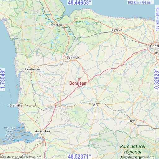
Domjean GPS coordinates[2]
48° 59' 14.136" North, 1° 1' 56.46" West
| Map corner | latitude | longitude |
|---|---|---|
| Upper-left | 49.44653°, | -1.73548° |
| Center: | 48.98726°, | -1.03235° |
| Lower-right: | 48.52371°, | -0.32923° |
| Map W x H: | 102.6×102.6 km | = 63.8×63.8mi |
| max Lat: | 51.07786° ⇑20.6% North |
| Domjean: | 48.98726° |
| min Lat: | ⇓79.4% South 41.3874° |
| min Long | Domjean | max Long |
| -5.08615° | -1.03235° | 9.52242° |
| W 11.6%⇐ | ⇒88.4% E |
Elevation
Elevation of Domjean is 90 m = 295 ft, and this is 103.7 m = 340 ft below average elevation for this country.
| Max E: |
2333 m = 7654 ft | 64.9% |
| Avg. | 193.7 m = 635 ft | |
| Domjean | 90 m = 295 ft | |
Min E: |
-1 m = -3 ft | 35.1% |
See also: France elevation on elevation.city.
Geographical zone
Domjean is located in North temperate zone (between Tropic of Cancer and the Arctic Circle). Distance of this North polar circle is 1954.3 km =1214.3 mi to North.| Distance of | km | miles | from Domjean |
|---|---|---|---|
| North Pole | 4560.2 | 2833.6 | to North |
| Arctic Circle | 1954.3 | 1214.3 | to North |
| Tropic Cancer | 2841 | 1765.3 | to South |
| Equator | 5446.9 | 3384.5 | to South |


Nearby cities:
15 places around Domjean: (largest is in red/bold)
• Campeaux
8.4 km =5.2 mi,  119°
119°
• Condé-sur-Vire
7 km =4.3 mi,  359°
359°
• Giéville
5 km =3.1 mi,  52°
52°
• Guilberville
6.5 km =4 mi,  88°
88°
• La Mancellière-sur-Vire
9.5 km =5.9 mi,  342°
342°
• Landelles-et-Coupigny
11.4 km =7.1 mi,  167°
167°
• Moyon
6.5 km =4 mi,  283°
283°
• Saint-Amand
7.9 km =4.9 mi,  38°
38°
• Saint-Martin-de-Bonfossé
12.4 km =7.7 mi,  305°
305°
• Saint-Romphaire
7.8 km =4.8 mi,  316°
316°
• Saint-Samson-de-Bonfossé
9.8 km =6.1 mi, 314°
• Saint-Ébremond-de-Bonfossé
12.4 km =7.7 mi, 316°
• Sainte-Suzanne-sur-Vire
8.5 km =5.3 mi,  346°
346°
• Tessy-sur-Vire
2.6 km =1.6 mi,  234°
234°
• Torigni-sur-Vire
6.6 km =4.1 mi,  33°
33°
Sources, notices
• [Note1] Compared only with cities in France existing in our database
• [Src1] Map data: © OpenStreetMap contributors (CC-BY-SA)
• [Src2] Other city data from geonames.org with taken over terms of usage.
• [Src3] Geographical zone / Annual Mean Temperature by Robert A. Rohde @ Wikipedia
