Grez-Neuville geodata
Grez-Neuville (Pays de la Loire) is a populated place; located in France in Europe/Paris (GMT+2) time zone. With population of 1,383 people, there are 6673 cities with bigger population in this country. Compared to other cities in France, 52.7% of cities are located further ↓South; 85.4% of cities are located further →East and 91.2% of cities have higher elevation than Grez-Neuville. Note1
Administrative division(s):
- Level 1: Pays de la Loire
- Level 2: Département de Maine-et-Loire
- Level 3: Arrondissement de Segré
- Level 4: Grez-Neuville


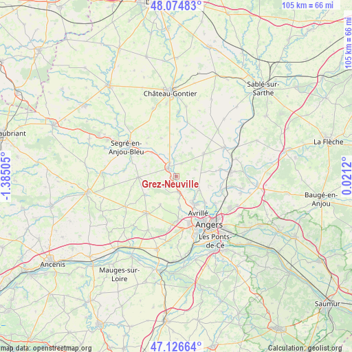
Grez-Neuville GPS coordinates[2]
47° 36' 10.368" North, 0° 40' 54.948" West
| Map corner | latitude | longitude |
|---|---|---|
| Upper-left | 48.07483°, | -1.38505° |
| Center: | 47.60288°, | -0.68193° |
| Lower-right: | 47.12664°, | 0.0212° |
| Map W x H: | 105.4×105.4 km | = 65.5×65.5mi |
| max Lat: | 51.07786° ⇑47.3% North |
| Grez-Neuville: | 47.60288° |
| min Lat: | ⇓52.7% South 41.3874° |
| min Long | Grez-Neuville | max Long |
| -5.08615° | -0.68193° | 9.52242° |
| W 14.6%⇐ | ⇒85.4% E |
Elevation
Elevation of Grez-Neuville is 27 m = 89 ft, and this is 166.7 m = 547 ft below average elevation for this country.
| Max E: |
2333 m = 7654 ft | 91.2% |
| Avg. | 193.7 m = 635 ft | |
| Grez-Neuville | 27 m = 89 ft | |
Min E: |
-1 m = -3 ft | 8.8% |
See also: France elevation on elevation.city.
Geographical zone
Grez-Neuville is located in North temperate zone (between Tropic of Cancer and the Arctic Circle). Distance of this North polar circle is 2108.2 km =1310 mi to North.| Distance of | km | miles | from Grez-Neuville |
|---|---|---|---|
| North Pole | 4714.1 | 2929.2 | to North |
| Arctic Circle | 2108.2 | 1310 | to North |
| Tropic Cancer | 2687 | 1669.6 | to South |
| Equator | 5292.9 | 3288.9 | to South |


Nearby cities:
15 places around Grez-Neuville: (largest is in red/bold)
• Brain-sur-Longuenée
6.3 km =3.9 mi,  251°
251°
• Cantenay-Épinard
11.3 km =7 mi,  131°
131°
• Champigné
10.7 km =6.6 mi,  50°
50°
• Feneu
7.4 km =4.6 mi,  117°
117°
• La Meignanne
9.6 km =6 mi,  174°
174°
• La Membrolle-sur-Longuenée
4.8 km =3 mi, 171°
• La Pouëze
11 km =6.8 mi,  240°
240°
• Le Plessis-Macé
6.7 km =4.2 mi,  175°
175°
• Montreuil-sur-Maine
5.4 km =3.4 mi,  347°
347°
• Pruillé
3.2 km =2 mi,  152°
152°
• Saint-Clément-de-la-Place
9.6 km =6 mi,  209°
209°
• Saint-Lambert-la-Potherie
13.3 km =8.3 mi, 178°
• Saint-Martin-du-Bois
12.4 km =7.7 mi,  338°
338°
• Soulaire-et-Bourg
10.1 km =6.3 mi,  105°
105°
• Vern-d’Anjou
11.4 km =7.1 mi,  269°
269°
Sources, notices
• [Note1] Compared only with cities in France existing in our database
• [Src1] Map data: © OpenStreetMap contributors (CC-BY-SA)
• [Src2] Other city data from geonames.org with taken over terms of usage.
• [Src3] Geographical zone / Annual Mean Temperature by Robert A. Rohde @ Wikipedia
