Glos geodata
Glos (Normandy) is a populated place; located in France in Europe/Paris (GMT+2) time zone. With population of 916 people, there are 9519 cities with bigger population in this country. Compared to other cities in France, 82.7% of cities are located further ↓South; 75.5% of cities are located further →East and 72.3% of cities have higher elevation than Glos. Note1
Administrative division(s):
- Level 1: Normandy
- Level 2: Calvados
- Level 3: Arrondissement de Lisieux
- Level 4: Glos


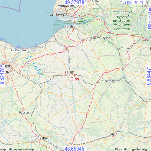
Glos GPS coordinates[2]
49° 7' 18.3" North, 0° 16' 52.86" East
| Map corner | latitude | longitude |
|---|---|---|
| Upper-left | 49.57978°, | -0.42178° |
| Center: | 49.12175°, | 0.28135° |
| Lower-right: | 48.65945°, | 0.98447° |
| Map W x H: | 102.3×102.3 km | = 63.6×63.6mi |
| max Lat: | 51.07786° ⇑17.3% North |
| Glos: | 49.12175° |
| min Lat: | ⇓82.7% South 41.3874° |
| min Long | Glos | max Long |
| -5.08615° | 0.28135° | 9.52242° |
| W 24.5%⇐ | ⇒75.5% E |
Elevation
Elevation of Glos is 73 m = 240 ft, and this is 120.7 m = 396 ft below average elevation for this country.
| Max E: |
2333 m = 7654 ft | 72.3% |
| Avg. | 193.7 m = 635 ft | |
| Glos | 73 m = 240 ft | |
Min E: |
-1 m = -3 ft | 27.7% |
See also: France elevation on elevation.city.
Geographical zone
Glos is located in North temperate zone (between Tropic of Cancer and the Arctic Circle). Distance of this North polar circle is 1939.3 km =1205 mi to North.| Distance of | km | miles | from Glos |
|---|---|---|---|
| North Pole | 4545.2 | 2824.3 | to North |
| Arctic Circle | 1939.3 | 1205 | to North |
| Tropic Cancer | 2855.9 | 1774.6 | to South |
| Equator | 5461.8 | 3393.8 | to South |


Nearby cities:
15 places around Glos: (largest is in red/bold)
• Beuvillers
2.1 km =1.3 mi,  294°
294°
• Courtonne-la-Meurdrac
2.8 km =1.7 mi,  81°
81°
• Courtonne-les-Deux-Églises
7.5 km =4.7 mi,  124°
124°
• Fervaques
9.2 km =5.7 mi,  192°
192°
• Hermival-les-Vaux
5.2 km =3.2 mi,  0°
0°
• La Chapelle-Yvon
7.7 km =4.8 mi,  146°
146°
• Le Mesnil-Guillaume
2 km =1.2 mi,  165°
165°
• Lisieux
4.7 km =2.9 mi,  306°
306°
• Marolles
6.9 km =4.3 mi,  74°
74°
• Ouilly-le-Vicomte
8 km =5 mi,  327°
327°
• Saint-Cyr-du-Ronceray
7.7 km =4.8 mi, 171°
• Saint-Désir
5.3 km =3.3 mi, 293°
• Saint-Germain-de-Livet
7.7 km =4.8 mi,  228°
228°
• Saint-Martin-de-Mailloc
3.6 km =2.2 mi,  156°
156°
• Saint-Martin-de-la-Lieue
4.8 km =3 mi,  257°
257°
Sources, notices
• [Note1] Compared only with cities in France existing in our database
• [Src1] Map data: © OpenStreetMap contributors (CC-BY-SA)
• [Src2] Other city data from geonames.org with taken over terms of usage.
• [Src3] Geographical zone / Annual Mean Temperature by Robert A. Rohde @ Wikipedia
