Hermival-les-Vaux geodata
Hermival-les-Vaux (Normandy) is a populated place; located in France in Europe/Paris (GMT+2) time zone. With population of 800 people, there are 10613 cities with bigger population in this country. Compared to other cities in France, 83.7% of cities are located further ↓South; 75.5% of cities are located further →East and 78.2% of cities have higher elevation than Hermival-les-Vaux. Note1
Administrative division(s):
- Level 1: Normandy
- Level 2: Calvados
- Level 3: Arrondissement de Lisieux
- Level 4: Hermival-les-Vaux


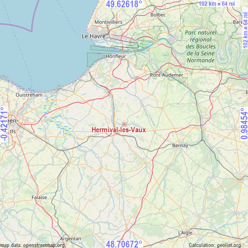
Hermival-les-Vaux GPS coordinates[2]
49° 10' 6.888" North, 0° 16' 53.112" East
| Map corner | latitude | longitude |
|---|---|---|
| Upper-left | 49.62618°, | -0.42171° |
| Center: | 49.16858°, | 0.28142° |
| Lower-right: | 48.70672°, | 0.98454° |
| Map W x H: | 102.2×102.2 km | = 63.5×63.5mi |
| max Lat: | 51.07786° ⇑16.3% North |
| Hermival-les-Vaux: | 49.16858° |
| min Lat: | ⇓83.7% South 41.3874° |
| min Long | Hermival-les-Va | max Long |
| -5.08615° | 0.28142° | 9.52242° |
| W 24.5%⇐ | ⇒75.5% E |
Elevation
Elevation of Hermival-les-Vaux is 59 m = 194 ft, and this is 134.7 m = 442 ft below average elevation for this country.
| Max E: |
2333 m = 7654 ft | 78.2% |
| Avg. | 193.7 m = 635 ft | |
| Hermival-les-Vaux | 59 m = 194 ft | |
Min E: |
-1 m = -3 ft | 21.8% |
See also: France elevation on elevation.city.
Geographical zone
Hermival-les-Vaux is located in North temperate zone (between Tropic of Cancer and the Arctic Circle). Distance of this North polar circle is 1934.1 km =1201.8 mi to North.| Distance of | km | miles | from Hermival-les-Vaux |
|---|---|---|---|
| North Pole | 4540 | 2821 | to North |
| Arctic Circle | 1934.1 | 1201.8 | to North |
| Tropic Cancer | 2861.1 | 1777.8 | to South |
| Equator | 5467 | 3397 | to South |


Nearby cities:
15 places around Hermival-les-Vaux: (largest is in red/bold)
• Beuvillers
4.7 km =2.9 mi,  203°
203°
• Coquainvilliers
6.1 km =3.8 mi,  301°
301°
• Courtonne-la-Meurdrac
5.5 km =3.4 mi,  149°
149°
• Glos
5.2 km =3.2 mi,  180°
180°
• Le Breuil-en-Auge
7.9 km =4.9 mi,  328°
328°
• Le Mesnil-Guillaume
7.1 km =4.4 mi, 176°
• Le Pin
6.1 km =3.8 mi,  39°
39°
• Lisieux
4.5 km =2.8 mi,  237°
237°
• Manerbe
8 km =5 mi,  283°
283°
• Marolles
7.4 km =4.6 mi,  116°
116°
• Moyaux
6.2 km =3.9 mi,  61°
61°
• Ouilly-le-Vicomte
4.5 km =2.8 mi,  290°
290°
• Saint-Désir
5.8 km =3.6 mi, 237°
• Saint-Martin-de-la-Lieue
7.8 km =4.8 mi,  216°
216°
• Saint-Philbert-des-Champs
4.5 km =2.8 mi,  1°
1°
Sources, notices
• [Note1] Compared only with cities in France existing in our database
• [Src1] Map data: © OpenStreetMap contributors (CC-BY-SA)
• [Src2] Other city data from geonames.org with taken over terms of usage.
• [Src3] Geographical zone / Annual Mean Temperature by Robert A. Rohde @ Wikipedia
