Courtonne-la-Meurdrac geodata
Courtonne-la-Meurdrac (Normandy) is a populated place; located in France in Europe/Paris (GMT+2) time zone. With population of 690 people, there are 11939 cities with bigger population in this country. Compared to other cities in France, 82.8% of cities are located further ↓South; 75.2% of cities are located further →East and 67% of cities have higher elevation than Courtonne-la-Meurdrac. Note1
Administrative division(s):
- Level 1: Normandy
- Level 2: Calvados
- Level 3: Arrondissement de Lisieux
- Level 4: Courtonne-la-Meurdrac
Current local time in Courtonne-la-Meurdrac:
03:22 PM, SaturdayDifference from your time zone: hours


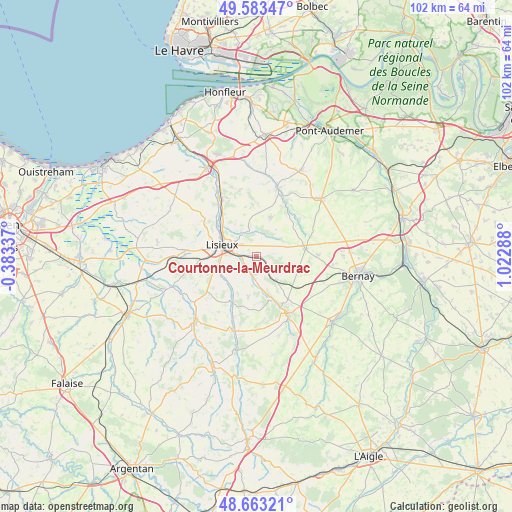
Courtonne-la-Meurdrac GPS coordinates[2]
49° 7' 31.692" North, 0° 19' 11.136" East
| Map corner | latitude | longitude |
|---|---|---|
| Upper-left | 49.58347°, | -0.38337° |
| Center: | 49.12547°, | 0.31976° |
| Lower-right: | 48.66321°, | 1.02288° |
| Map W x H: | 102.3×102.3 km | = 63.6×63.6mi |
| max Lat: | 51.07786° ⇑17.2% North |
| Courtonne-la-Meurdrac: | 49.12547° |
| min Lat: | ⇓82.8% South 41.3874° |
| min Long | Courtonne-la-Me | max Long |
| -5.08615° | 0.31976° | 9.52242° |
| W 24.8%⇐ | ⇒75.2% E |
Elevation
Elevation of Courtonne-la-Meurdrac is 85 m = 279 ft, and this is 108.7 m = 357 ft below average elevation for this country.
| Max E: |
2333 m = 7654 ft | 67% |
| Avg. | 193.7 m = 635 ft | |
| Courtonne-la-Meurdrac | 85 m = 279 ft | |
Min E: |
-1 m = -3 ft | 33% |
See also: France elevation on elevation.city.
Geographical zone
Courtonne-la-Meurdrac is located in North temperate zone (between Tropic of Cancer and the Arctic Circle). Distance of this North polar circle is 1938.9 km =1204.8 mi to North.| Distance of | km | miles | from Courtonne-la-Meurdrac |
|---|---|---|---|
| North Pole | 4544.8 | 2824 | to North |
| Arctic Circle | 1938.9 | 1204.8 | to North |
| Tropic Cancer | 2856.3 | 1774.8 | to South |
| Equator | 5462.2 | 3394.1 | to South |


Nearby cities:
15 places around Courtonne-la-Meurdrac: (largest is in red/bold)
• Beuvillers
4.7 km =2.9 mi,  275°
275°
• Courtonne-les-Deux-Églises
5.8 km =3.6 mi,  143°
143°
• Glos
2.8 km =1.7 mi,  261°
261°
• Hermival-les-Vaux
5.5 km =3.4 mi,  329°
329°
• La Chapelle-Yvon
7 km =4.3 mi,  168°
168°
• Le Mesnil-Guillaume
3.3 km =2.1 mi,  225°
225°
• Le Pin
9.6 km =6 mi,  6°
6°
• Lisieux
7 km =4.3 mi,  289°
289°
• Marolles
4.1 km =2.5 mi,  69°
69°
• Moyaux
8.2 km =5.1 mi,  18°
18°
• Ouilly-le-Vicomte
9.5 km =5.9 mi,  312°
312°
• Saint-Cyr-du-Ronceray
8.2 km =5.1 mi,  191°
191°
• Saint-Désir
7.9 km =4.9 mi, 282°
• Saint-Martin-de-Mailloc
3.9 km =2.4 mi,  200°
200°
• Saint-Martin-de-la-Lieue
7.6 km =4.7 mi, 259°
Sources, notices
• [Note1] Compared only with cities in France existing in our database
• [Src1] Map data: © OpenStreetMap contributors (CC-BY-SA)
• [Src2] Other city data from geonames.org with taken over terms of usage.
• [Src3] Geographical zone / Annual Mean Temperature by Robert A. Rohde @ Wikipedia
