Ouilly-le-Vicomte geodata
Ouilly-le-Vicomte (Normandy) is a populated place; located in France in Europe/Paris (GMT+2) time zone. With population of 834 people, there are 10255 cities with bigger population in this country. Compared to other cities in France, 84% of cities are located further ↓South; 76% of cities are located further →East and 83.8% of cities have higher elevation than Ouilly-le-Vicomte. Note1
Administrative division(s):
- Level 1: Normandy
- Level 2: Calvados
- Level 3: Arrondissement de Lisieux
- Level 4: Ouilly-le-Vicomte


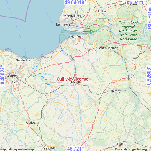
Ouilly-le-Vicomte GPS coordinates[2]
49° 10' 57.828" North, 0° 13' 22.44" East
| Map corner | latitude | longitude |
|---|---|---|
| Upper-left | 49.64019°, | -0.48022° |
| Center: | 49.18273°, | 0.2229° |
| Lower-right: | 48.721°, | 0.92603° |
| Map W x H: | 102.2×102.2 km | = 63.5×63.5mi |
| max Lat: | 51.07786° ⇑16% North |
| Ouilly-le-Vicomte: | 49.18273° |
| min Lat: | ⇓84% South 41.3874° |
| min Long | Ouilly-le-Vicom | max Long |
| -5.08615° | 0.2229° | 9.52242° |
| W 24%⇐ | ⇒76% E |
Elevation
Elevation of Ouilly-le-Vicomte is 45 m = 148 ft, and this is 148.7 m = 488 ft below average elevation for this country.
| Max E: |
2333 m = 7654 ft | 83.8% |
| Avg. | 193.7 m = 635 ft | |
| Ouilly-le-Vicomte | 45 m = 148 ft | |
Min E: |
-1 m = -3 ft | 16.2% |
See also: France elevation on elevation.city.
Geographical zone
Ouilly-le-Vicomte is located in North temperate zone (between Tropic of Cancer and the Arctic Circle). Distance of this North polar circle is 1932.6 km =1200.9 mi to North.| Distance of | km | miles | from Ouilly-le-Vicomte |
|---|---|---|---|
| North Pole | 4538.5 | 2820.1 | to North |
| Arctic Circle | 1932.6 | 1200.9 | to North |
| Tropic Cancer | 2862.7 | 1778.8 | to South |
| Equator | 5468.6 | 3398 | to South |


Nearby cities:
15 places around Ouilly-le-Vicomte: (largest is in red/bold)
• Beuvillers
6.3 km =3.9 mi,  158°
158°
• Blangy-le-Château
7.6 km =4.7 mi,  28°
28°
• Coquainvilliers
1.9 km =1.2 mi,  330°
330°
• Courtonne-la-Meurdrac
9.5 km =5.9 mi,  132°
132°
• Glos
8 km =5 mi,  147°
147°
• Hermival-les-Vaux
4.5 km =2.8 mi,  110°
110°
• Le Breuil-en-Auge
5.1 km =3.2 mi,  1°
1°
• Le Pin
8.7 km =5.4 mi,  68°
68°
• Lisieux
4 km =2.5 mi,  173°
173°
• Manerbe
3.6 km =2.2 mi,  273°
273°
• Moyaux
9.8 km =6.1 mi,  81°
81°
• Saint-Désir
4.7 km =2.9 mi,  187°
187°
• Saint-Hymer
8.6 km =5.3 mi,  335°
335°
• Saint-Martin-de-la-Lieue
7.8 km =4.8 mi,  182°
182°
• Saint-Philbert-des-Champs
5.2 km =3.2 mi,  56°
56°
Sources, notices
• [Note1] Compared only with cities in France existing in our database
• [Src1] Map data: © OpenStreetMap contributors (CC-BY-SA)
• [Src2] Other city data from geonames.org with taken over terms of usage.
• [Src3] Geographical zone / Annual Mean Temperature by Robert A. Rohde @ Wikipedia
