Giverny geodata
Giverny (Normandy) is a populated place; located in France in Europe/Paris (GMT+2) time zone. With population of 564 people, there are 13934 cities with bigger population in this country. Compared to other cities in France, 81.6% of cities are located further ↓South; 62.6% of cities are located further →East and 91.2% of cities have higher elevation than Giverny. Note1
Administrative division(s):
- Level 1: Normandy
- Level 2: Département de l'Eure
- Level 3: Les Andelys
- Level 4: Giverny


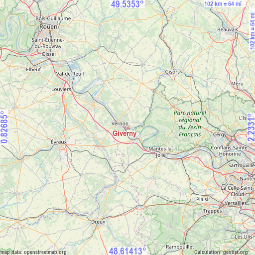
Giverny GPS coordinates[2]
49° 4' 36.66" North, 1° 31' 47.928" East
| Map corner | latitude | longitude |
|---|---|---|
| Upper-left | 49.5353°, | 0.82685° |
| Center: | 49.07685°, | 1.52998° |
| Lower-right: | 48.61413°, | 2.2331° |
| Map W x H: | 102.4×102.4 km | = 63.6×63.6mi |
| max Lat: | 51.07786° ⇑18.4% North |
| Giverny: | 49.07685° |
| min Lat: | ⇓81.6% South 41.3874° |
| min Long | Giverny | max Long |
| -5.08615° | 1.52998° | 9.52242° |
| W 37.4%⇐ | ⇒62.6% E |
Elevation
Elevation of Giverny is 27 m = 89 ft, and this is 166.7 m = 547 ft below average elevation for this country.
| Max E: |
2333 m = 7654 ft | 91.2% |
| Avg. | 193.7 m = 635 ft | |
| Giverny | 27 m = 89 ft | |
Min E: |
-1 m = -3 ft | 8.8% |
See also: France elevation on elevation.city.
Geographical zone
Giverny is located in North temperate zone (between Tropic of Cancer and the Arctic Circle). Distance of this North polar circle is 1944.3 km =1208.1 mi to North.| Distance of | km | miles | from Giverny |
|---|---|---|---|
| North Pole | 4550.2 | 2827.4 | to North |
| Arctic Circle | 1944.3 | 1208.1 | to North |
| Tropic Cancer | 2850.9 | 1771.5 | to South |
| Equator | 5456.8 | 3390.7 | to South |


Nearby cities:
15 places around Giverny: (largest is in red/bold)
• Bennecourt
4.3 km =2.7 mi,  155°
155°
• Blaru
4.9 km =3 mi,  228°
228°
• Bois-Jérôme-Saint-Ouen
3 km =1.9 mi,  6°
6°
• Bonnières-sur-Seine
5.8 km =3.6 mi,  142°
142°
• Freneuse
6.1 km =3.8 mi,  121°
121°
• Gasny
5.6 km =3.5 mi,  72°
72°
• Gommecourt
5.2 km =3.2 mi,  81°
81°
• La Roche-Guyon
7.3 km =4.5 mi,  86°
86°
• La Villeneuve-en-Chevrie
6.9 km =4.3 mi,  181°
181°
• Limetz-Villez
1.8 km =1.1 mi,  127°
127°
• Saint-Just
7.4 km =4.6 mi,  298°
298°
• Saint-Marcel
6.4 km =4 mi,  293°
293°
• Sainte-Geneviève-lès-Gasny
4.1 km =2.5 mi, 80°
• Tilly
7.6 km =4.7 mi,  359°
359°
• Vernon
5.2 km =3.2 mi, 290°
Sources, notices
• [Note1] Compared only with cities in France existing in our database
• [Src1] Map data: © OpenStreetMap contributors (CC-BY-SA)
• [Src2] Other city data from geonames.org with taken over terms of usage.
• [Src3] Geographical zone / Annual Mean Temperature by Robert A. Rohde @ Wikipedia
