La Roche-Guyon geodata
La Roche-Guyon (Île-de-France) is a populated place; located in France in Europe/Paris (GMT+2) time zone. With population of 583 people, there are 13590 cities with bigger population in this country. Compared to other cities in France, 81.7% of cities are located further ↓South; 61.3% of cities are located further →East and 89.9% of cities have higher elevation than La Roche-Guyon. Note1
Administrative division(s):
- Level 1: Île-de-France
- Level 2: Département du Val-d’Oise
- Level 3: Arrondissement de Pontoise
- Level 4: La Roche-Guyon


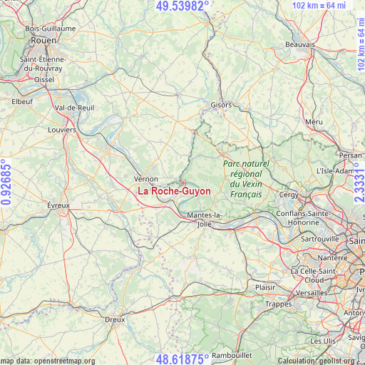
La Roche-Guyon GPS coordinates[2]
49° 4' 53.112" North, 1° 37' 47.928" East
| Map corner | latitude | longitude |
|---|---|---|
| Upper-left | 49.53982°, | 0.92685° |
| Center: | 49.08142°, | 1.62998° |
| Lower-right: | 48.61875°, | 2.3331° |
| Map W x H: | 102.4×102.4 km | = 63.6×63.6mi |
| max Lat: | 51.07786° ⇑18.3% North |
| La Roche-Guyon: | 49.08142° |
| min Lat: | ⇓81.7% South 41.3874° |
| min Long | La Roche-Guyon | max Long |
| -5.08615° | 1.62998° | 9.52242° |
| W 38.7%⇐ | ⇒61.3% E |
Elevation
Elevation of La Roche-Guyon is 30 m = 98 ft, and this is 163.7 m = 537 ft below average elevation for this country.
| Max E: |
2333 m = 7654 ft | 89.9% |
| Avg. | 193.7 m = 635 ft | |
| La Roche-Guyon | 30 m = 98 ft | |
Min E: |
-1 m = -3 ft | 10.1% |
See also: France elevation on elevation.city.
Geographical zone
La Roche-Guyon is located in North temperate zone (between Tropic of Cancer and the Arctic Circle). Distance of this North polar circle is 1943.8 km =1207.8 mi to North.| Distance of | km | miles | from La Roche-Guyon |
|---|---|---|---|
| North Pole | 4549.7 | 2827.1 | to North |
| Arctic Circle | 1943.8 | 1207.8 | to North |
| Tropic Cancer | 2851.4 | 1771.8 | to South |
| Equator | 5457.3 | 3391 | to South |


Nearby cities:
15 places around La Roche-Guyon: (largest is in red/bold)
• Bennecourt
7.1 km =4.4 mi,  231°
231°
• Bonnières-sur-Seine
6.4 km =4 mi,  216°
216°
• Bray-et-Lû
6.6 km =4.1 mi,  16°
16°
• Chaussy
6.4 km =4 mi,  44°
44°
• Fourges
4.5 km =2.8 mi,  9°
9°
• Freneuse
4.2 km =2.6 mi,  209°
209°
• Gasny
2.3 km =1.4 mi,  300°
300°
• Giverny
7.3 km =4.5 mi,  266°
266°
• Gommecourt
2.2 km =1.4 mi,  275°
275°
• Limetz-Villez
6.1 km =3.8 mi,  254°
254°
• Moisson
3 km =1.9 mi,  107°
107°
• Mousseaux-sur-Seine
4.3 km =2.7 mi,  163°
163°
• Saint-Martin-la-Garenne
6.2 km =3.9 mi,  136°
136°
• Sainte-Geneviève-lès-Gasny
3.3 km =2.1 mi, 273°
• Vétheuil
5.8 km =3.6 mi, 111°
Sources, notices
• [Note1] Compared only with cities in France existing in our database
• [Src1] Map data: © OpenStreetMap contributors (CC-BY-SA)
• [Src2] Other city data from geonames.org with taken over terms of usage.
• [Src3] Geographical zone / Annual Mean Temperature by Robert A. Rohde @ Wikipedia
