Girolles geodata
Girolles (Centre) is a populated place; located in France in Europe/Paris (GMT+2) time zone. With population of 629 people, there are 12831 cities with bigger population in this country. Compared to other cities in France, 60.4% of cities are located further ↓South; 53.7% of cities are located further ←West and 61.5% of cities have higher elevation than Girolles. Note1
Administrative division(s):
- Level 1: Centre
- Level 2: Loiret
- Level 3: Arrondissement de Montargis
- Level 4: Girolles


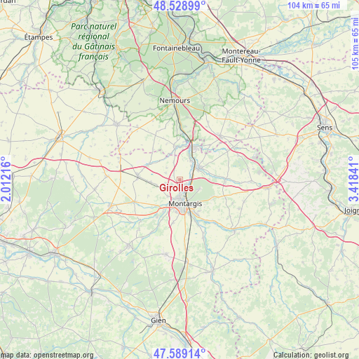
Girolles GPS coordinates[2]
48° 3' 40.356" North, 2° 42' 55.008" East
| Map corner | latitude | longitude |
|---|---|---|
| Upper-left | 48.52899°, | 2.01216° |
| Center: | 48.06121°, | 2.71528° |
| Lower-right: | 47.58914°, | 3.41841° |
| Map W x H: | 104.5×104.5 km | = 64.9×64.9mi |
| max Lat: | 51.07786° ⇑39.6% North |
| Girolles: | 48.06121° |
| min Lat: | ⇓60.4% South 41.3874° |
| min Long | Girolles | max Long |
| -5.08615° | 2.71528° | 9.52242° |
| W 53.7%⇐ | ⇒46.3% E |
Elevation
Elevation of Girolles is 98 m = 322 ft, and this is 95.7 m = 314 ft below average elevation for this country.
| Max E: |
2333 m = 7654 ft | 61.5% |
| Avg. | 193.7 m = 635 ft | |
| Girolles | 98 m = 322 ft | |
Min E: |
-1 m = -3 ft | 38.5% |
See also: France elevation on elevation.city.
Geographical zone
Girolles is located in North temperate zone (between Tropic of Cancer and the Arctic Circle). Distance of this North polar circle is 2057.3 km =1278.3 mi to North.| Distance of | km | miles | from Girolles |
|---|---|---|---|
| North Pole | 4663.2 | 2897.6 | to North |
| Arctic Circle | 2057.3 | 1278.3 | to North |
| Tropic Cancer | 2738 | 1701.3 | to South |
| Equator | 5343.9 | 3320.5 | to South |


Nearby cities:
15 places around Girolles: (largest is in red/bold)
• Amilly
10.7 km =6.6 mi,  156°
156°
• Cepoy
2.2 km =1.4 mi,  131°
131°
• Châlette-sur-Loing
5.5 km =3.4 mi, 163°
• Château-Landon
9.7 km =6 mi,  352°
352°
• Corquilleroy
2.3 km =1.4 mi,  201°
201°
• Dordives
9.8 km =6.1 mi,  23°
23°
• Fontenay-sur-Loing
6.5 km =4 mi,  43°
43°
• Griselles
8.8 km =5.5 mi,  73°
73°
• Montargis
7.3 km =4.5 mi,  169°
169°
• Nargis
6.3 km =3.9 mi,  28°
28°
• Pannes
5.9 km =3.7 mi,  217°
217°
• Paucourt
6.5 km =4 mi,  113°
113°
• Saint-Maurice-sur-Fessard
10.4 km =6.5 mi, 222°
• Sceaux-du-Gâtinais
10.2 km =6.3 mi,  299°
299°
• Villemandeur
8.3 km =5.2 mi,  178°
178°
Sources, notices
• [Note1] Compared only with cities in France existing in our database
• [Src1] Map data: © OpenStreetMap contributors (CC-BY-SA)
• [Src2] Other city data from geonames.org with taken over terms of usage.
• [Src3] Geographical zone / Annual Mean Temperature by Robert A. Rohde @ Wikipedia
