Châlette-sur-Loing geodata
Châlette-sur-Loing (Centre) is a populated place; located in France in Europe/Paris (GMT+2) time zone. With population of 14,268 people, there are 672 cities with bigger population in this country. Compared to other cities in France, 59.5% of cities are located further ↓South; 54% of cities are located further ←West and 67% of cities have higher elevation than Châlette-sur-Loing. Note1
Administrative division(s):
- Level 1: Centre
- Level 2: Loiret
- Level 3: Arrondissement de Montargis
- Level 4: Châlette-sur-Loing


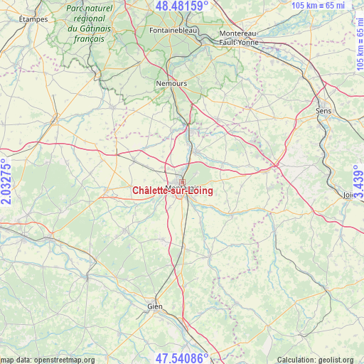
Châlette-sur-Loing GPS coordinates[2]
48° 0' 48.132" North, 2° 44' 9.132" East
| Map corner | latitude | longitude |
|---|---|---|
| Upper-left | 48.48159°, | 2.03275° |
| Center: | 48.01337°, | 2.73587° |
| Lower-right: | 47.54086°, | 3.439° |
| Map W x H: | 104.6×104.6 km | = 65×65mi |
| max Lat: | 51.07786° ⇑40.5% North |
| Châlette-sur-Loing: | 48.01337° |
| min Lat: | ⇓59.5% South 41.3874° |
| min Long | Châlette-sur-L | max Long |
| -5.08615° | 2.73587° | 9.52242° |
| W 54%⇐ | ⇒46% E |
Elevation
Elevation of Châlette-sur-Loing is 85 m = 279 ft, and this is 108.7 m = 357 ft below average elevation for this country.
| Max E: |
2333 m = 7654 ft | 67% |
| Avg. | 193.7 m = 635 ft | |
| Châlette-sur-Loing | 85 m = 279 ft | |
Min E: |
-1 m = -3 ft | 33% |
See also: France elevation on elevation.city.
Geographical zone
Châlette-sur-Loing is located in North temperate zone (between Tropic of Cancer and the Arctic Circle). Distance of this North polar circle is 2062.6 km =1281.6 mi to North.| Distance of | km | miles | from Châlette-sur-Loing |
|---|---|---|---|
| North Pole | 4668.5 | 2900.9 | to North |
| Arctic Circle | 2062.6 | 1281.6 | to North |
| Tropic Cancer | 2732.7 | 1698 | to South |
| Equator | 5338.6 | 3317.3 | to South |


Nearby cities:
15 places around Châlette-sur-Loing: (largest is in red/bold)
• Amilly
5.2 km =3.2 mi,  149°
149°
• Cepoy
3.8 km =2.4 mi,  2°
2°
• Chevillon-sur-Huillard
10 km =6.2 mi,  235°
235°
• Corquilleroy
4 km =2.5 mi,  323°
323°
• Fontenay-sur-Loing
10.5 km =6.5 mi,  16°
16°
• Girolles
5.5 km =3.4 mi,  343°
343°
• Griselles
10.4 km =6.5 mi,  41°
41°
• Montargis
1.8 km =1.1 mi,  187°
187°
• Nargis
11 km =6.8 mi,  7°
7°
• Pannes
5.1 km =3.2 mi,  277°
277°
• Paucourt
5.2 km =3.2 mi,  58°
58°
• Saint-Germain-des-Prés
10.7 km =6.6 mi,  128°
128°
• Saint-Maurice-sur-Fessard
8.8 km =5.5 mi,  254°
254°
• Villemandeur
3.2 km =2 mi,  204°
204°
• Vimory
8.1 km =5 mi,  206°
206°
Sources, notices
• [Note1] Compared only with cities in France existing in our database
• [Src1] Map data: © OpenStreetMap contributors (CC-BY-SA)
• [Src2] Other city data from geonames.org with taken over terms of usage.
• [Src3] Geographical zone / Annual Mean Temperature by Robert A. Rohde @ Wikipedia
