Gidy geodata
Gidy (Centre) is a populated place; located in France in Europe/Paris (GMT+2) time zone. With population of 1,580 people, there are 5903 cities with bigger population in this country. Compared to other cities in France, 59% of cities are located further ↓South; 59% of cities are located further →East and 53.1% of cities have higher elevation than Gidy. Note1
Administrative division(s):
- Level 1: Centre
- Level 2: Loiret
- Level 3: Arrondissement d’Orléans
- Level 4: Gidy


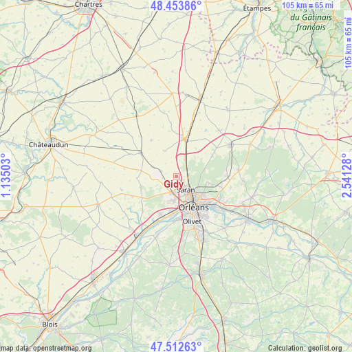
Gidy GPS coordinates[2]
47° 59' 7.404" North, 1° 50' 17.376" East
| Map corner | latitude | longitude |
|---|---|---|
| Upper-left | 48.45386°, | 1.13503° |
| Center: | 47.98539°, | 1.83816° |
| Lower-right: | 47.51263°, | 2.54128° |
| Map W x H: | 104.7×104.7 km | = 65.1×65.1mi |
| max Lat: | 51.07786° ⇑41% North |
| Gidy: | 47.98539° |
| min Lat: | ⇓59% South 41.3874° |
| min Long | Gidy | max Long |
| -5.08615° | 1.83816° | 9.52242° |
| W 41%⇐ | ⇒59% E |
Elevation
Elevation of Gidy is 122 m = 400 ft, and this is 71.7 m = 235 ft below average elevation for this country.
| Max E: |
2333 m = 7654 ft | 53.1% |
| Avg. | 193.7 m = 635 ft | |
| Gidy | 122 m = 400 ft | |
Min E: |
-1 m = -3 ft | 46.9% |
See also: France elevation on elevation.city.
Geographical zone
Gidy is located in North temperate zone (between Tropic of Cancer and the Arctic Circle). Distance of this North polar circle is 2065.7 km =1283.6 mi to North.| Distance of | km | miles | from Gidy |
|---|---|---|---|
| North Pole | 4671.6 | 2902.8 | to North |
| Arctic Circle | 2065.7 | 1283.6 | to North |
| Tropic Cancer | 2729.6 | 1696.1 | to South |
| Equator | 5335.5 | 3315.3 | to South |


Nearby cities:
15 places around Gidy: (largest is in red/bold)
• Boulay-les-Barres
4.2 km =2.6 mi,  267°
267°
• Bricy
4.6 km =2.9 mi,  288°
288°
• Cercottes
3.3 km =2.1 mi,  88°
88°
• Chanteau
10.1 km =6.3 mi,  101°
101°
• Chevilly
5.6 km =3.5 mi,  28°
28°
• Fleury-les-Aubrais
8.3 km =5.2 mi,  134°
134°
• Ingré
7.3 km =4.5 mi,  186°
186°
• La Chapelle-Saint-Mesmin
11 km =6.8 mi,  181°
181°
• Orléans
10.4 km =6.5 mi,  151°
151°
• Ormes
5.1 km =3.2 mi,  196°
196°
• Saint-Jean-de-la-Ruelle
8.5 km =5.3 mi,  166°
166°
• Saint-Péravy-la-Colombe
10.3 km =6.4 mi,  278°
278°
• Saran
4.8 km =3 mi,  144°
144°
• Semoy
10.1 km =6.3 mi,  124°
124°
• Sougy
8.5 km =5.3 mi,  333°
333°
Sources, notices
• [Note1] Compared only with cities in France existing in our database
• [Src1] Map data: © OpenStreetMap contributors (CC-BY-SA)
• [Src2] Other city data from geonames.org with taken over terms of usage.
• [Src3] Geographical zone / Annual Mean Temperature by Robert A. Rohde @ Wikipedia
