Gerde geodata
Gerde (Occitanie) is a populated place; located in France in Europe/Paris (GMT+2) time zone. With population of 1,170 people, there are 7711 cities with bigger population in this country. Compared to other cities in France, 98.2% of cities are located further ↑North; 76.5% of cities are located further →East and 95% of cities have lower elevation than Gerde. Note1
Administrative division(s):
- Level 1: Occitanie
- Level 2: Département des Hautes-Pyrénées
- Level 3: Arrondissement de Bagnères-de-Bigorre
- Level 4: Gerde


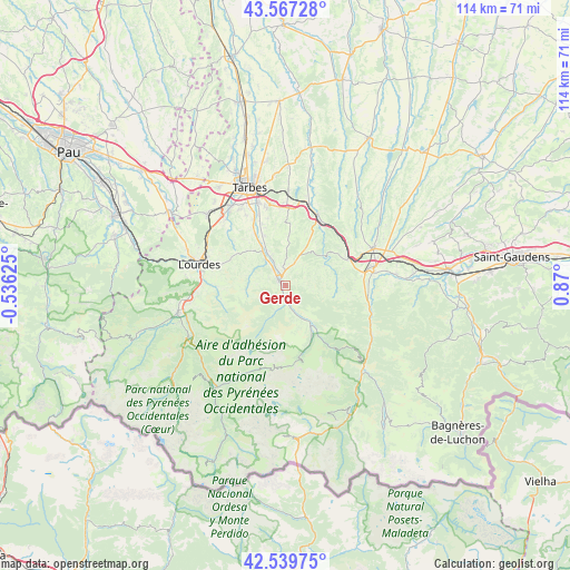
Gerde GPS coordinates[2]
43° 3' 20.412" North, 0° 10' 0.768" East
| Map corner | latitude | longitude |
|---|---|---|
| Upper-left | 43.56728°, | -0.53625° |
| Center: | 43.05567°, | 0.16688° |
| Lower-right: | 42.53975°, | 0.87° |
| Map W x H: | 114.3×114.2 km | = 71×71mi |
| max Lat: | 51.07786° ⇑98.2% North |
| Gerde: | 43.05567° |
| min Lat: | ⇓1.8% South 41.3874° |
| min Long | Gerde | max Long |
| -5.08615° | 0.16688° | 9.52242° |
| W 23.5%⇐ | ⇒76.5% E |
Elevation
Elevation of Gerde is 584 m = 1916 ft, and this is 390.3 m = 1281 ft above average elevation for this country.
| Max E: |
2333 m = 7654 ft | 5% |
| Gerde | 584 m 1916 ft | |
| Avg. | 193.7 m = 635 ft | |
Min E: |
-1 m = -3 ft | 95% |
See also: France elevation on elevation.city.
Geographical zone
Gerde is located in North temperate zone (between Tropic of Cancer and the Arctic Circle). Distance of this Northern Tropic circle is 2181.4 km =1355.5 mi to South.| Distance of | km | miles | from Gerde |
|---|---|---|---|
| North Pole | 5219.7 | 3243.4 | to North |
| Arctic Circle | 2613.8 | 1624.1 | to North |
| Tropic Cancer | 2181.4 | 1355.5 | to South |
| Equator | 4787.3 | 2974.7 | to South |


Nearby cities:
15 places around Gerde: (largest is in red/bold)
• Asté
1.7 km =1.1 mi,  172°
172°
• Avezac-Prat-Lahitte
13.6 km =8.5 mi,  84°
84°
• Bagnères-de-Bigorre
1.7 km =1.1 mi,  304°
304°
• Barbazan-Debat
16 km =9.9 mi,  346°
346°
• Bernac-Debat
13.4 km =8.3 mi,  338°
338°
• Bénac
15.8 km =9.8 mi,  313°
313°
• Campan
4.5 km =2.8 mi, 167°
• Capvern
13.2 km =8.2 mi,  66°
66°
• Cieutat
8.5 km =5.3 mi,  27°
27°
• Horgues
16.1 km =10 mi, 336°
• Momères
15 km =9.3 mi, 335°
• Montgaillard
9.1 km =5.7 mi,  327°
327°
• Pouzac
4.2 km =2.6 mi,  322°
322°
• Tournay
15.6 km =9.7 mi,  23°
23°
• Trébons
6.4 km =4 mi, 323°
Sources, notices
• [Note1] Compared only with cities in France existing in our database
• [Src1] Map data: © OpenStreetMap contributors (CC-BY-SA)
• [Src2] Other city data from geonames.org with taken over terms of usage.
• [Src3] Geographical zone / Annual Mean Temperature by Robert A. Rohde @ Wikipedia
