Bagnères-de-Bigorre geodata
Bagnères-de-Bigorre (Occitanie) is a seat of a third-order administrative division; located in France in Europe/Paris (GMT+2) time zone. With population of 8,967 people, there are 1075 cities with bigger population in this country. Compared to other cities in France, 98.2% of cities are located further ↑North; 76.8% of cities are located further →East and 94.5% of cities have lower elevation than Bagnères-de-Bigorre. Note1
Administrative division(s):
- Level 1: Occitanie
- Level 2: Département des Hautes-Pyrénées
- Level 3: Arrondissement de Bagnères-de-Bigorre
- Level 4: Bagnères-de-Bigorre


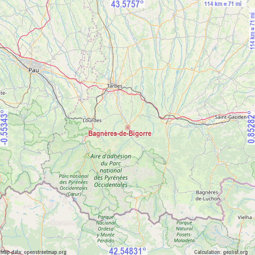
Bagnères-de-Bigorre GPS coordinates[2]
43° 3' 50.976" North, 0° 8' 58.92" East
| Map corner | latitude | longitude |
|---|---|---|
| Upper-left | 43.5757°, | -0.55343° |
| Center: | 43.06416°, | 0.1497° |
| Lower-right: | 42.54831°, | 0.85282° |
| Map W x H: | 114.2×114.2 km | = 71×71mi |
| max Lat: | 51.07786° ⇑98.2% North |
| Bagnères-de-Bigorre: | 43.06416° |
| min Lat: | ⇓1.8% South 41.3874° |
| min Long | Bagnères-de-Bi | max Long |
| -5.08615° | 0.1497° | 9.52242° |
| W 23.2%⇐ | ⇒76.8% E |
Elevation
Elevation of Bagnères-de-Bigorre is 560 m = 1837 ft, and this is 366.3 m = 1202 ft above average elevation for this country.
| Max E: |
2333 m = 7654 ft | 5.5% |
| Bagnères-de-Bigorre | 560 m 1837 ft | |
| Avg. | 193.7 m = 635 ft | |
Min E: |
-1 m = -3 ft | 94.5% |
See also: France elevation on elevation.city.
Geographical zone
Bagnères-de-Bigorre is located in North temperate zone (between Tropic of Cancer and the Arctic Circle). Distance of this Northern Tropic circle is 2182.4 km =1356.1 mi to South.| Distance of | km | miles | from Bagnères-de-Bigorre |
|---|---|---|---|
| North Pole | 5218.8 | 3242.8 | to North |
| Arctic Circle | 2612.9 | 1623.6 | to North |
| Tropic Cancer | 2182.4 | 1356.1 | to South |
| Equator | 4788.3 | 2975.3 | to South |


Nearby cities:
15 places around Bagnères-de-Bigorre: (largest is in red/bold)
• Asté
3 km =1.9 mi,  148°
148°
• Avezac-Prat-Lahitte
14.9 km =9.3 mi,  88°
88°
• Barbazan-Debat
14.8 km =9.2 mi,  350°
350°
• Bernac-Debat
12 km =7.5 mi,  343°
343°
• Bénac
14.2 km =8.8 mi,  314°
314°
• Campan
5.9 km =3.7 mi,  156°
156°
• Capvern
14.2 km =8.8 mi,  72°
72°
• Cieutat
8.5 km =5.3 mi,  39°
39°
• Gerde
1.7 km =1.1 mi,  124°
124°
• Horgues
14.7 km =9.1 mi, 339°
• Momères
13.6 km =8.5 mi, 338°
• Montgaillard
7.6 km =4.7 mi,  333°
333°
• Pouzac
2.7 km =1.7 mi, 334°
• Tournay
15.4 km =9.6 mi,  29°
29°
• Trébons
4.8 km =3 mi, 330°
Sources, notices
• [Note1] Compared only with cities in France existing in our database
• [Src1] Map data: © OpenStreetMap contributors (CC-BY-SA)
• [Src2] Other city data from geonames.org with taken over terms of usage.
• [Src3] Geographical zone / Annual Mean Temperature by Robert A. Rohde @ Wikipedia
