Avezac-Prat-Lahitte geodata
Avezac-Prat-Lahitte (Occitanie) is a populated place; located in France in Europe/Paris (GMT+2) time zone. With population of 551 people, there are 14194 cities with bigger population in this country. Compared to other cities in France, 98.2% of cities are located further ↑North; 75% of cities are located further →East and 94.9% of cities have lower elevation than Avezac-Prat-Lahitte. Note1
Administrative division(s):
- Level 1: Occitanie
- Level 2: Département des Hautes-Pyrénées
- Level 3: Arrondissement de Bagnères-de-Bigorre
- Level 4: Avezac-Prat-Lahitte


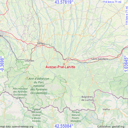
Avezac-Prat-Lahitte GPS coordinates[2]
43° 4' 0.012" North, 0° 19' 59.988" East
| Map corner | latitude | longitude |
|---|---|---|
| Upper-left | 43.57819°, | -0.3698° |
| Center: | 43.06667°, | 0.33333° |
| Lower-right: | 42.55084°, | 1.03645° |
| Map W x H: | 114.2×114.2 km | = 71×71mi |
| max Lat: | 51.07786° ⇑98.2% North |
| Avezac-Prat-Lahitte: | 43.06667° |
| min Lat: | ⇓1.8% South 41.3874° |
| min Long | Avezac-Prat-Lah | max Long |
| -5.08615° | 0.33333° | 9.52242° |
| W 25%⇐ | ⇒75% E |
Elevation
Elevation of Avezac-Prat-Lahitte is 580 m = 1903 ft, and this is 386.3 m = 1267 ft above average elevation for this country.
| Max E: |
2333 m = 7654 ft | 5.1% |
| Avezac-Prat-Lahitte | 580 m 1903 ft | |
| Avg. | 193.7 m = 635 ft | |
Min E: |
-1 m = -3 ft | 94.9% |
See also: France elevation on elevation.city.
Geographical zone
Avezac-Prat-Lahitte is located in North temperate zone (between Tropic of Cancer and the Arctic Circle). Distance of this Northern Tropic circle is 2182.6 km =1356.2 mi to South.| Distance of | km | miles | from Avezac-Prat-Lahitte |
|---|---|---|---|
| North Pole | 5218.5 | 3242.6 | to North |
| Arctic Circle | 2612.6 | 1623.4 | to North |
| Tropic Cancer | 2182.6 | 1356.2 | to South |
| Equator | 4788.6 | 2975.5 | to South |


Nearby cities:
15 places around Avezac-Prat-Lahitte: (largest is in red/bold)
• Asté
13.6 km =8.5 mi,  257°
257°
• Bagnères-de-Bigorre
14.9 km =9.3 mi,  268°
268°
• Bordes
17.3 km =10.7 mi,  329°
329°
• Campan
13.8 km =8.6 mi,  245°
245°
• Capvern
4.3 km =2.7 mi,  341°
341°
• Cieutat
11.4 km =7.1 mi,  303°
303°
• Gerde
13.6 km =8.5 mi, 264°
• Hèches
6.5 km =4 mi,  150°
150°
• La Barthe-de-Neste
4.5 km =2.8 mi,  68°
68°
• Lannemezan
7.7 km =4.8 mi,  32°
32°
• Pouzac
16.2 km =10.1 mi,  277°
277°
• Saint-Laurent-de-Neste
12.2 km =7.6 mi,  84°
84°
• Sarrancolin
11.5 km =7.1 mi,  160°
160°
• Tournay
14.9 km =9.3 mi, 331°
• Trébons
17.7 km =11 mi, 282°
Sources, notices
• [Note1] Compared only with cities in France existing in our database
• [Src1] Map data: © OpenStreetMap contributors (CC-BY-SA)
• [Src2] Other city data from geonames.org with taken over terms of usage.
• [Src3] Geographical zone / Annual Mean Temperature by Robert A. Rohde @ Wikipedia
